IMAGES TAKEN NEAR TO
Twittenside, Penfold Way, STEYNING, BN44 3TW
Introduction
This page details the photographs taken nearby to Twittenside, Penfold Way, BN44 3TW by members of the Geograph project.
The Geograph project started in 2005 with the aim of publishing, organising and preserving representative images for every square kilometre of Great Britain, Ireland and the Isle of Man.

There are currently over 7.5m images from over14,400 individuals and you can help contribute to the project by visiting https://www.geograph.org.uk
Image Map
Images are licensed for reuse under creativecommons.org/licenses/by-sa/2.0
Notes
- Clicking on the map will re-center to the selected point.
- The higher the marker number, the further away the image location is from the centre of the postcode.
Image Listing (315 Images Found)
Images are licensed for reuse under creativecommons.org/licenses/by-sa/2.0
Image
Details
Distance
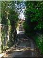
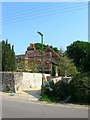
1
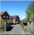
Twittenside, Steyning
A cul de sac off Penfold Way that was developed sometime in the 2000s. The titular twitten on the right links the close to Dog Lane.
Image: © Simon Carey
Taken: 1 May 2016
0.02 miles
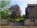
2
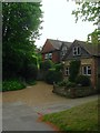
Watersmead, Dog Lane, Steyning
Located on the corner of Dog Lane with the footpath to Penfold Way just visible next to the drive. The house dates from the mid 20th century and was once home to performers Elsie & Doris Waters better known as Gert & Daisy. The sisters moved to Steyning before the Second World War and stayed for the rest of their lives, moving from here to a bungalow on Goring Road.
Image: © Simon Carey
Taken: 15 May 2016
0.03 miles
3
The dog-leg of Dog Lane
See also http://www.geograph.org.uk/photo/4939633.
Image: © Shazz
Taken: 30 Sep 2016
0.03 miles
4
Old Orchard, Dog Lane, Steyning
Located on the bend in Dog Lane it appears the house was built in the last quarter of the 19th century as it doesn't appear on the 1875 OS map and the grounds were indeed an orchard.
Image: © Simon Carey
Taken: 1 May 2016
0.03 miles
5
Dog Lane, Steyning
Linking the High Street with Sheep Pen Lane. Previously known as Brewery Lane as marked on the first three OS maps of 1875, 1897 and 1911. By the 1932 edition it had obtained its current name.
Image: © Simon Carey
Taken: 1 May 2016
0.04 miles
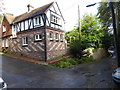
6
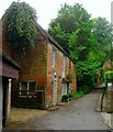
The Granary, Dog Lane, Steyning
Another outbuilding that once belonged to Mitchell's Brewery. Later known as Rosewall Barn it appear to have been used at some point as a tea room but was converted into residential use in the early 1990s. The change of name seems to be from a later date.
Image: © Simon Carey
Taken: 15 May 2016
0.04 miles
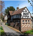
7
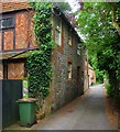
Old Brewery Barn, Dog Lane, Steyning
A former 17th century barn that was once part of Mitchell's Brewery. It was converted into a residence in the late 1980s or early 1990s. Beyond is Image
Image: © Simon Carey
Taken: 15 May 2016
0.05 miles
8
Faggs Barn, Dog Lane, Steyning
A former barn dating from the 17th century that has been converted into a residence.
Image: © Simon Carey
Taken: 1 May 2016
0.06 miles
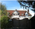
9
Newham House, Sheep Pen Lane, Steyning
Originally a timber framed house from the 15th or 16th century that was altered in the 18th and 20th centuries. The path on the right leads to Dog Lane.
Image: © Simon Carey
Taken: 5 Jun 2016
0.06 miles
10
Dukes Lane, Steyning
A cul de sac off Neewham Lane built in the late 1980s on the site of F.Duke Ltd.s former builders yard. Beyond the house in view the land drops down to a former brewery pond.
Image: © Simon Carey
Taken: 5 Jun 2016
0.06 miles