IMAGES TAKEN NEAR TO
Dacre Gardens, STEYNING, BN44 3TD
Introduction
This page details the photographs taken nearby to Dacre Gardens, BN44 3TD by members of the Geograph project.
The Geograph project started in 2005 with the aim of publishing, organising and preserving representative images for every square kilometre of Great Britain, Ireland and the Isle of Man.

There are currently over 7.5m images from over14,400 individuals and you can help contribute to the project by visiting https://www.geograph.org.uk
Image Map
Images are licensed for reuse under creativecommons.org/licenses/by-sa/2.0
Notes
- Clicking on the map will re-center to the selected point.
- The higher the marker number, the further away the image location is from the centre of the postcode.
Image Listing (69 Images Found)
Images are licensed for reuse under creativecommons.org/licenses/by-sa/2.0
Image
Details
Distance
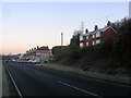
3

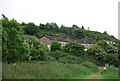
Dacre Gardens
Housing built between 1896 and 1909 for the employees of the nearby Beeding Cement Works.
Image: © Simon Carey
Taken: 7 Dec 2008
0.01 miles
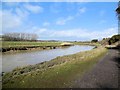
4
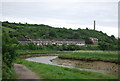
Dacre Gardens
Terraced houses originally built for workers employed by Beeding cement works, whose chimney is to the right. Viewed from the banks of the River Adur.
Image: © Simon Carey
Taken: 15 Dec 2007
0.02 miles
6
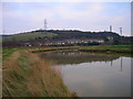
Dacre Villas and Dacre Gardens
Built as company housing for the nearby cement works. Dacre Villas was completed in 1903 whilst the longer row of Dacre Gardens were built between 1896 and 1909. I like to the think that perhaps the works foremen occupied Dacre Villas whilst the workers lived in Dacre Gardens.
Image: © Simon Carey
Taken: 7 Dec 2008
0.05 miles
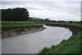
7
River Adur near Botolphs
Between Shoreham and Bramber viewed from the Downs Link
Image: © Paul Gillett
Taken: 23 Feb 2015
0.06 miles
9
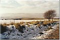
The Adur Valley
A view from the Monarch's Way over Anchor Bottom
Image: © Peter Jeffery
Taken: Unknown
0.07 miles
10
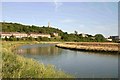
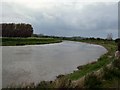
The River Adur
A sweep of the river passing the "Cement Works Cottages" with the disused cement works on the background.
Image: © Peter Jeffery
Taken: 1 Jul 2006
0.08 miles