IMAGES TAKEN NEAR TO
Tanyard Lane, STEYNING, BN44 3RR
Introduction
This page details the photographs taken nearby to Tanyard Lane, BN44 3RR by members of the Geograph project.
The Geograph project started in 2005 with the aim of publishing, organising and preserving representative images for every square kilometre of Great Britain, Ireland and the Isle of Man.

There are currently over 7.5m images from over14,400 individuals and you can help contribute to the project by visiting https://www.geograph.org.uk
Image Map
Images are licensed for reuse under creativecommons.org/licenses/by-sa/2.0
Notes
- Clicking on the map will re-center to the selected point.
- The higher the marker number, the further away the image location is from the centre of the postcode.
Image Listing (487 Images Found)
Images are licensed for reuse under creativecommons.org/licenses/by-sa/2.0
Image
Details
Distance
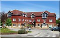
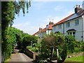
1

Stonecroft, Tanyard Lane, Steyning
Houses located on the northern side of Tanyard Lane that are built over the top of Tanyard Stream, though the stream had long been culverted prior to them being built sometime in the late 1930s.
Image: © Simon Carey
Taken: 15 May 2016
0.01 miles
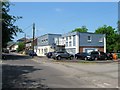
2
The Health Centre, Tanyard Lane, Steyning
Built in the 1970s along with neighbouring Image
Image: © Simon Carey
Taken: 8 May 2016
0.05 miles
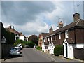
3

Highland Croft, Steyning
A housing estate begun in the 1930s and completed by the 1950s and bounded by Tanyard Lane, Elmgrove Lane, Chantry Lane and the rear of the houses in Church Street. A small access road runs diagonally down the middle following the course of ancient right of way which remains a public footpath today.
Image: © Simon Carey
Taken: 15 May 2016
0.05 miles
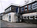
4
Total House, Tanyard Lane, Steyning
A commercial premises home to a number of small businesses on the corner of Tanyard Lane and Breach Close. The site was original the location of GW Breach & Co's leather works that operated here from the early 19th century until its closure in 1941.
Image: © Simon Carey
Taken: 29 May 2016
0.06 miles
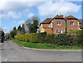
6
Thornscroft, Steyning
A small estate that circles a small green off Shooting Field that was built in the 1940s and was originally accessed via Tanyard Lane until the Shooting Field estate was completed in the 1950s.
Image: © Simon Carey
Taken: 8 May 2016
0.06 miles
7
Elm Grove Lane, Steyning
A narrow thoroughfare linking High Street to Tanyard Lane. It was called Back Lane on a 1791 map, Newmans Lane on all OS maps from 1876 to 1932, acquiring its current name either before or after the Second World War. The houses on the right are actually part of Highland Croft.
Image: © Simon Carey
Taken: 29 May 2016
0.06 miles
8
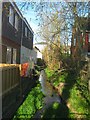
Tanyard Stream
A tributary of the River Adur that rises less than a mile to the west and joins the main watercourse near King's Barn. The stream powered a mill to the west and a tannery on the eastern bank in view which opened sometime in the early 19th century and closed in 1941 having spent much of its life processing sheepskins into leather. Of the tannery's buildings only a warehouse survives today. Viewed from Breach Close.
Image: © Simon Carey
Taken: 1 May 2016
0.06 miles
9
Gatewick Terrace, Tanyard Lane, Steyning
Built sometime in the early 19th century possibly for employees of the nearby flour mill, see Image
Image: © Simon Carey
Taken: 15 May 2016
0.07 miles
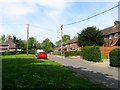
10
Coxham Lane
Once connected Horsham Road with Tanyard Lane but now only the former entrance remains though at this point a footpath from Tanyard Lane that eventually heads out of town to the north crosses over the lane.
Image: © Simon Carey
Taken: 8 Mar 2009
0.07 miles