IMAGES TAKEN NEAR TO
Thornscroft, STEYNING, BN44 3RP
Introduction
This page details the photographs taken nearby to Thornscroft, BN44 3RP by members of the Geograph project.
The Geograph project started in 2005 with the aim of publishing, organising and preserving representative images for every square kilometre of Great Britain, Ireland and the Isle of Man.

There are currently over 7.5m images from over14,400 individuals and you can help contribute to the project by visiting https://www.geograph.org.uk
Image Map
Images are licensed for reuse under creativecommons.org/licenses/by-sa/2.0
Notes
- Clicking on the map will re-center to the selected point.
- The higher the marker number, the further away the image location is from the centre of the postcode.
Image Listing (479 Images Found)
Images are licensed for reuse under creativecommons.org/licenses/by-sa/2.0
Image
Details
Distance
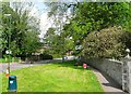
1
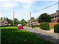
Thornscroft, Steyning
A small estate that circles a small green off Shooting Field that was built in the 1940s and was originally accessed via Tanyard Lane until the Shooting Field estate was completed in the 1950s.
Image: © Simon Carey
Taken: 8 May 2016
0.01 miles
2
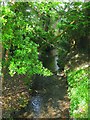
Tanyard Stream
Viewed from Shooting Field adjacent to the junction with Tanyard Lane. The stream rises to the west of Steyning and joins the River Adur east of Kings Barn Farm and over the centuries has powered a couple of mills and a tannery.
Image: © Simon Carey
Taken: 8 May 2016
0.05 miles
3
Gatewick Terrace, Tanyard Lane, Steyning
Built sometime in the early 19th century possibly for employees of the nearby flour mill, see Image
Image: © Simon Carey
Taken: 15 May 2016
0.05 miles
4
Shooting Field, Steyning
The cul de sac is off the main access road also called Shooting Field and is part of an estate built in the late 1940s and early 1950s. The estate is named after the large field it was built on.
Image: © Simon Carey
Taken: 8 May 2016
0.05 miles
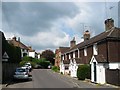
5

Stonecroft, Tanyard Lane, Steyning
Houses located on the northern side of Tanyard Lane that are built over the top of Tanyard Stream, though the stream had long been culverted prior to them being built sometime in the late 1930s.
Image: © Simon Carey
Taken: 15 May 2016
0.06 miles
6
Site of Gatewick Mill Pond, Steyning
Looking along the boundary wall of Gatewick House towards the bridge over Tanyard Stream. There had been a mill at this location since at least the 13th century and survived until 1878 when it was demolished. The mill pond was filled in and is now the location of the entrance to Shooting Field estate.
Image: © Simon Carey
Taken: 15 May 2016
0.06 miles
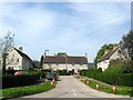
7

Highland Croft, Steyning
A housing estate begun in the 1930s and completed by the 1950s and bounded by Tanyard Lane, Elmgrove Lane, Chantry Lane and the rear of the houses in Church Street. A small access road runs diagonally down the middle following the course of ancient right of way which remains a public footpath today.
Image: © Simon Carey
Taken: 15 May 2016
0.07 miles
8
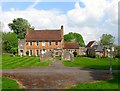
Gatewick House, Steyning
Originally a manor house built on island formed by Tanyard Stream and a mill race belonging to an adjacent mill (see Image) that has now been filled in. The house dates from the 17th century with the brick facade added in the 18th. The archway in the foreground was also added in the 18th century utilising materials from an older building. The crenellated battlement was probably built at the same time.
Image: © Simon Carey
Taken: 15 May 2016
0.08 miles
10
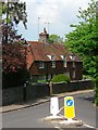
Church Lane, Steyning
A small lane linking Church Street to Tanyard Lane containing just the two houses in view. Originally a single medieval timber framed hall house which was refaced sometime during the 18th century.
Image: © Simon Carey
Taken: 15 May 2016
0.09 miles