IMAGES TAKEN NEAR TO
Penlands Close, STEYNING, BN44 3PH
Introduction
This page details the photographs taken nearby to Penlands Close, BN44 3PH by members of the Geograph project.
The Geograph project started in 2005 with the aim of publishing, organising and preserving representative images for every square kilometre of Great Britain, Ireland and the Isle of Man.

There are currently over 7.5m images from over14,400 individuals and you can help contribute to the project by visiting https://www.geograph.org.uk
Image Map
Images are licensed for reuse under creativecommons.org/licenses/by-sa/2.0
Notes
- Clicking on the map will re-center to the selected point.
- The higher the marker number, the further away the image location is from the centre of the postcode.
Image Listing (76 Images Found)
Images are licensed for reuse under creativecommons.org/licenses/by-sa/2.0
Image
Details
Distance
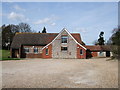
1
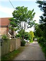
Penlands Close, Steyning
An unmade cul de sac off Bostal Road that was developed in the 1960s.
Image: © Simon Carey
Taken: 29 May 2016
0.02 miles
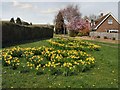
2
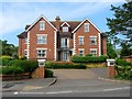
Wheat House, Goring Court, Bramber Road, Steyning
Built around 2000 on the site of Penland House, a late Victorian house in large grounds. The development contains two blocks with Barley House out of shot to the left.
Image: © Simon Carey
Taken: 29 May 2016
0.03 miles
3
Greenacres, Steyning
A cul de sac off Penlands Way that was developed in the 1960s.
Image: © Simon Carey
Taken: 29 May 2016
0.03 miles
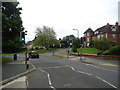
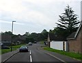
7
Offset crossroads at Steyning
The road opposite is Bostal Road, a narrow lane that starts at Sompting on the A27, then climbs the southern slopes of the South Downs via the top of Steyning Hill to drop sharply into Steyning.
Image: © Dave Spicer
Taken: 28 Sep 2011
0.05 miles
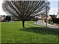
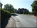
8
Road sign and house at the bottom of Bostal Road
'Bostal' is a local word for a steep track up the South Downs. There are several 'bostals' in Sussex.
Image: © Ian Hawfinch
Taken: 21 Mar 2020
0.05 miles
10
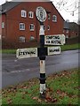
Direction Sign ? Signpost
Located on the southeast side of the junction of Clays Hill, Bramber Road and Bostal Road in Steyning parish. 3 arms and disc finial.
Milestone Society National ID: SX_TQ1710
Image: © D Ivey
Taken: 20 Jan 2019
0.05 miles