IMAGES TAKEN NEAR TO
College Hill, STEYNING, BN44 3NN
Introduction
This page details the photographs taken nearby to College Hill, BN44 3NN by members of the Geograph project.
The Geograph project started in 2005 with the aim of publishing, organising and preserving representative images for every square kilometre of Great Britain, Ireland and the Isle of Man.

There are currently over 7.5m images from over14,400 individuals and you can help contribute to the project by visiting https://www.geograph.org.uk
Image Map
Images are licensed for reuse under creativecommons.org/licenses/by-sa/2.0
Notes
- Clicking on the map will re-center to the selected point.
- The higher the marker number, the further away the image location is from the centre of the postcode.
Image Listing (239 Images Found)
Images are licensed for reuse under creativecommons.org/licenses/by-sa/2.0
Image
Details
Distance
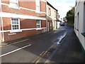
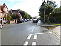
1
College Hill, Steyning
Looking down towards the junction with High Street. The road had been laid out in the 1890s on land formerly owned by the Grammar School trustees. The building on the right containing Norton and Devonshire was one of two structures that lined the road on the 1897 OS map.
Image: © Simon Carey
Taken: 15 May 2016
0.02 miles
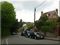
2
Ashburton Lodge, High Street, Steyning
Originally the lodge for Image and thus built sometime in the 19th century. Now a private residence.
Image: © Simon Carey
Taken: 5 Jun 2016
0.03 miles
3
2, High Street, Steyning
Located on the eastern corner of Jarvis Lane with Image beyond. The building seems to date from the 19th century and is currently occupied by a veterinary clinic.
Image: © Simon Carey
Taken: 29 May 2016
0.03 miles
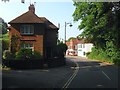
4
Wish House, High Street, Steyning
Built after the First World War and located next to the junction with College Hill. The house was constructed after the numbering of High Street and thus does not possess one as the house to the left is Image the first number on the eastern side of the street.
Image: © Simon Carey
Taken: 29 May 2016
0.04 miles
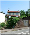
5
Bidlington Cottage, High Street, Steyning
Built fairly recently in the grounds of Image with just the roof visible over the high surrounding flint walls.
Image: © Simon Carey
Taken: 29 May 2016
0.04 miles
6
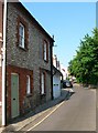
Old Brewery Cottage, Jarvis lane, Steyning
Built in the mid 19th century and once part of a former brewery complex that lined the north western part of the lane. The brewery was known as Gates's and was established in the early 19th century. In 1899 it amalgamated with Stovolds on the High Street to become Steyning Breweries which continued in operation until 1927 when that was purchased by Brighton's Rock Brewery who subsequently closed the buildings and transferred production elsewhere. Much of the former brewery was demolished except for this building, Image and the former brewery tap, Image All have now been converted into residential dwellings.
Image: © Simon Carey
Taken: 5 Jun 2016
0.05 miles
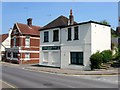
7
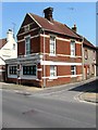
4, High Street, Steyning
Located on the western corner of Jarvis Lane and currently occupied by a dentist. The flint fronted cottage beyond is Old Brewery Cottage one of the survivors of Gates's Brewery which occupied part of Jarvis Lane from the early 19th century until the end of the 1920s. The brewery tap was the former Three Tuns Inn to the left, see Image
Image: © Simon Carey
Taken: 29 May 2016
0.05 miles
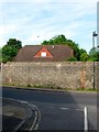
9
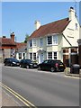
Three Tuns House, High Street, Steyning
The building dates from the 18th century and was the brewery tap for neighbouring Gates's Brewery which is marked on the 1876 OS map as Three Tuns brewery. The brewery closed in the late 1920s and most of the former buildings were demolished. However, the Three Tuns survived into the 1980s but I'm not sure when it finally closed. The former inn has been divided into a couple of residential dwellings.
Image: © Simon Carey
Taken: 29 May 2016
0.05 miles