IMAGES TAKEN NEAR TO
Horsham Road, STEYNING, BN44 3LJ
Introduction
This page details the photographs taken nearby to Horsham Road, BN44 3LJ by members of the Geograph project.
The Geograph project started in 2005 with the aim of publishing, organising and preserving representative images for every square kilometre of Great Britain, Ireland and the Isle of Man.

There are currently over 7.5m images from over14,400 individuals and you can help contribute to the project by visiting https://www.geograph.org.uk
Image Map
Images are licensed for reuse under creativecommons.org/licenses/by-sa/2.0
Notes
- Clicking on the map will re-center to the selected point.
- The higher the marker number, the further away the image location is from the centre of the postcode.
Image Listing (199 Images Found)
Images are licensed for reuse under creativecommons.org/licenses/by-sa/2.0
Image
Details
Distance
1
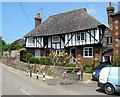
Penn's House, Horsham Road, Steyning
Built as a timber framed dwelling in the early 17th century. In 1678 it was purchased by the Quakers who turned into a meeting hall which was often visited by William Penn who resided for a while at Warminghurst to the north west of Steyning. The building was converted into a house around 1886 though sometime in the 1970s the then owners, themselves Quakers, opened their house to worshippers. The building is now subdivided into two dwellings, the northern part being known as Penn's Cottage.
Image: © Simon Carey
Taken: 25 Jun 2016
0.01 miles
2
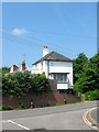
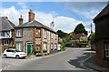
Ridge Mount, Horsham Road, Steyning
Built in the first half of the 19th century and placed at a right angle to the road it is the easternmost of a terrace of four.
Image: © Simon Carey
Taken: 29 May 2016
0.02 miles
3
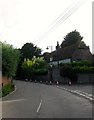
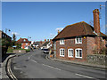
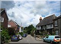
Horsham Road, Steyning
Looking towards the junction with High Street and Mouse Lane where the road takes a sharp right. On the left is Image whilst to the right is Image
Image: © Simon Carey
Taken: 25 Jun 2016
0.04 miles
4
Old Workhouse Cottages, Mouse Lane, Steyning
Originally built in the 15th century as a Wealden hall house it was acquired by the local borough in 1729 to be used as a workhouse which it remained until closure in 1835 when a new larger poor law union house was established in Shoreham which later became Southlands Hospital. It reverted to residential use and is now divided into three dwellings.
Image: © Simon Carey
Taken: 29 May 2016
0.04 miles
5
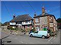
Windsor Cottage, Horsham Road, Steyning
Built in the 1740s and located at the junction of High Street, Mouse Lane and Horsham Road. Currently used as a holiday home.
Image: © Simon Carey
Taken: 15 May 2016
0.04 miles
6
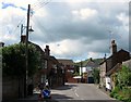
High Street
The western end of the main village street just before it heads out of town. In the distance is the old poorhouse built in the 16th century and on the junction of High Street, Horsham Road and Mouse Lane, the latter being the ancient western route out of town before being superseded by a turnpike in the early 19th century that is the current A283.
Image: © Simon Carey
Taken: 8 Mar 2009
0.04 miles
7
Steyning - Historic Houses
End on Mouse Lane.
The medieval timber framed building served as the areas work house.
Workhouse info : http://www.workhouses.org.uk/Steyning/
Wikipedia : https://en.wikipedia.org/wiki/Workhouse
Image: © James Emmans
Taken: 2 Apr 2017
0.04 miles
8
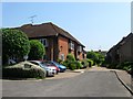
Penns Court, Steyning
A cul de sac containing sheltered housing that was constructed in 1990 on the former site of Steyning Gas Works. The works had been established by the late 1850s but closed sometime in the 1960s or 70s though a gasholder remained here during the 1980s.
Image: © Simon Carey
Taken: 29 May 2016
0.04 miles
9

Holly Cottage, High Street, Steyning
Number 136a was once the stables belonging to neighbouring Image but has been converted into a holiday cottage. One of two buildings with the name the other can be found at Image
Image: © Simon Carey
Taken: 29 May 2016
0.05 miles
10
Mouse Lane, Steyning
For many centuries this was the main highway heading west out of Steyning towards Washington. In 1810 with the help of the residents of Wiston House a new turnpike was laid out to the north which later became the A283. On the right is Image whilst on the left the white terraced cottages are Image The name of the road was first recorded in 1581.
Image: © Simon Carey
Taken: 25 Jun 2016
0.05 miles