IMAGES TAKEN NEAR TO
Jarvis Lane, STEYNING, BN44 3GU
Introduction
This page details the photographs taken nearby to Jarvis Lane, BN44 3GU by members of the Geograph project.
The Geograph project started in 2005 with the aim of publishing, organising and preserving representative images for every square kilometre of Great Britain, Ireland and the Isle of Man.

There are currently over 7.5m images from over14,400 individuals and you can help contribute to the project by visiting https://www.geograph.org.uk
Image Map
Images are licensed for reuse under creativecommons.org/licenses/by-sa/2.0
Notes
- Clicking on the map will re-center to the selected point.
- The higher the marker number, the further away the image location is from the centre of the postcode.
Image Listing (393 Images Found)
Images are licensed for reuse under creativecommons.org/licenses/by-sa/2.0
Image
Details
Distance
1
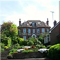
St John's, Jarvis Lane, Steyning
A large villa built sometime between 1897-1911. This is the rear view from the end of King Alfred's Close.
Image: © Simon Carey
Taken: 8 May 2016
0.01 miles
2
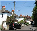
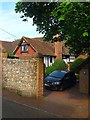
Jarvis Cottages, Jarvis Lane, Steyning
Located opposite the junction with Holland Road. Not marked on Steyning's 1841 tithe map but do appear on the 1876 OS map.
Image: © Simon Carey
Taken: 29 May 2016
0.02 miles
3
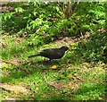
Blackbird, Cuthman's Field, Steyning
A male blackbird has just grabbed an insect from a nearby tree and is in the process of killing and devouring it.
Image: © Simon Carey
Taken: 8 May 2016
0.02 miles
4
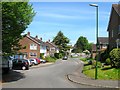
King Alfred's Close, Steyning
A cul de sac off Vicarage Lane that was built sometime during the 1960s.
Image: © Simon Carey
Taken: 8 May 2016
0.04 miles
5
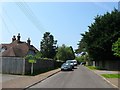
Holland Road, Steyning
A residential road that connects Jarvis Lane to Goring Road that was laid out in the first decade of the 20th century. The road actually follows a more ancient right of way which contiunes eastward from Goring Road. The house on the left is Saffrons.
Image: © Simon Carey
Taken: 29 May 2016
0.05 miles
6
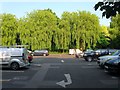
Fletchers Croft Car Park, Steyning
Opened in the late 1960s on the site of a former field called Fletchers Croft according to Steynings 1841 tithe map. It is a long stay car park and can be accessed via Vicarage Lane by car and School lane by foot.
Image: © Simon Carey
Taken: 5 Jun 2016
0.06 miles
7
Jarvis, Jarvis Lane, Steyning
A former 15th century farmhouse now engulfed by the urban growth of Steyning.
Image: © Simon Carey
Taken: 29 May 2016
0.06 miles
8
Junction Cripps Lane and Jarvis Lane
Image: © Josie Campbell
Taken: 14 Aug 2011
0.06 miles
9
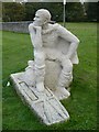
Sculpture of St. Cuthman on St. Cuthman's Field opposite the church
Created by Penelope Reeve in the year 2000.
Image: © pam fray
Taken: 18 Sep 2008
0.06 miles
10
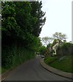
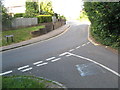
Cripps Lane, Steyning
An old highway that heads north from Jarvis Lane then becomes Vicarage Lane beyond the junction with Station Road at the foot of the slope. Beyond the church the road changes name again to Church Street.
Image: © Simon Carey
Taken: 15 May 2016
0.06 miles