IMAGES TAKEN NEAR TO
Oxford Terrace, Jarvis Lane, STEYNING, BN44 3GN
Introduction
This page details the photographs taken nearby to Oxford Terrace, Jarvis Lane, BN44 3GN by members of the Geograph project.
The Geograph project started in 2005 with the aim of publishing, organising and preserving representative images for every square kilometre of Great Britain, Ireland and the Isle of Man.

There are currently over 7.5m images from over14,400 individuals and you can help contribute to the project by visiting https://www.geograph.org.uk
Image Map
Images are licensed for reuse under creativecommons.org/licenses/by-sa/2.0
Notes
- Clicking on the map will re-center to the selected point.
- The higher the marker number, the further away the image location is from the centre of the postcode.
Image Listing (421 Images Found)
Images are licensed for reuse under creativecommons.org/licenses/by-sa/2.0
Image
Details
Distance
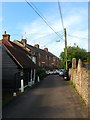
1
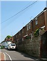
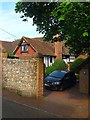
Oxford Terrace, Jarvis Lane, Steyning
There is a stone plaque above number one at the far end which gives a date of building which I could roughly make out as 1928. This makes sense as the previous building was one located with Gates's Brewery which closed in 1927. The brick work on the retaining wall in the foreground certainly looks older than that used by the houses. Beyond is Image
Image: © Simon Carey
Taken: 29 May 2016
0.00 miles
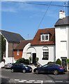
2
Herods Foot, Jarvis Lane, Steyning
Dating from the late 18th century or early 19th century the cottage is believed to be the last remnant of the Napoleonic barracks that were situated to the rear of the property and operated from 1804-19. The cottage was used by the officers.
Image: © Simon Carey
Taken: 29 May 2016
0.01 miles
3
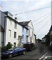
Jarvis Hall, Jarvis Lane, Steyning
A former nonconformist chapel that was built in 1835 for the Countess of Huntingdon's evangelical church. It wasn't a success and was sold to the Wesleyans in 1843 who would remain here until 1878 when they moved to another premises on the High Street, see Image The building was taken on by Kilner & Burgess who used it as a mineral water bottling plant until 1883 when it was acquired by the Salvation Army and returned to religious use. In 1907 the chapel was taken over by the Plymouth Brethren who became the longest occupants finally closing the premises for worship in 1987. The building was converted into flats soon after.
On the left is Chapel House originally known as Ambrose and along with its blue faced neighbour, Atherton, dates from the early 19th century.
Image: © Simon Carey
Taken: 29 May 2016
0.02 miles
4
The Malt House, Castle Lane, Steyning
One of the few remnants of the former Gates's Brewery which was located on Jarvis Lane beyond the junction to the left. The brewery was established in the early 19th century and was known as Three Tuns Brewery for a while until it merged with neighbouring Mitchell's (See Image) in 1899 to become Steyning Breweries. This business lasted until 1927 when it was acquired by Rock Breweries of Brighton who appear to have closed the brewery and demolished the main buildings as no trace can be found on the 1932 OS map. This store and a former cottage on Jarvis Lane near the junction with High Street are all that remains.
Image: © Simon Carey
Taken: 29 May 2016
0.02 miles
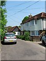
5
The Nest, Jarvis Lane, Steyning
The Nest is the small single storey building on the left which appears to be of some antiquity. Beyond partially obscured is Image and Image
Image: © Simon Carey
Taken: 29 May 2016
0.03 miles
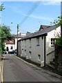
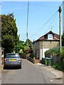
6
Malthouse Cottage, Jarvis Lane, Steyning
Built in the early 19th century and located next to the site of the former Gates's Brewery and over the road from Image one of the few surviving buildings.
Image: © Simon Carey
Taken: 29 May 2016
0.03 miles
7
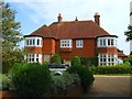
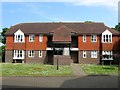
Clivedale, Castle Lane, Steyning
A large late Victorian town house that was converted into flats sometime during the 1980s.
Image: © Simon Carey
Taken: 29 May 2016
0.04 miles
8
Jarvis Lodge, Jarvis Lane, Steyning
Located opposite Image and is a former carriage house. During the 1930s the owners of Jarvis set up a charity called Jarvis Lodge which gave board in the building for a deserving widow of the parish. The Victoria History notes that the arrangement was ongoing in 1968 but I have no idea if it continues today.
Image: © Simon Carey
Taken: 29 May 2016
0.04 miles
9
Jarvis, Jarvis Lane, Steyning
A former 15th century farmhouse now engulfed by the urban growth of Steyning.
Image: © Simon Carey
Taken: 29 May 2016
0.04 miles
10
Tunsgate, Jarvis Lane, Steyning
The current development dates from about 1993 and replaced St Andrew's Hall and a garage. However, the latter had been built on the site of a former brewery that had existed here from the early 19th century. On the 1876 OS map it was called Three Tuns Brewery but was later known as Gates's. In 1899 it amalgamated with Stovolds not too far away on the High Street becoming Steyning Breweries Ltd until 1927 when they were taken over by Brighton's Rock Brewery who appear to have closed both by the 1932 OS map. The only survivors of the brewery is an old cottage and a former malthouse, the latter located further up the hill on the corner of Castle Lane, see Image
Image: © Simon Carey
Taken: 29 May 2016
0.05 miles