IMAGES TAKEN NEAR TO
Spithandle Lane, STEYNING, BN44 3DS
Introduction
This page details the photographs taken nearby to Spithandle Lane, BN44 3DS by members of the Geograph project.
The Geograph project started in 2005 with the aim of publishing, organising and preserving representative images for every square kilometre of Great Britain, Ireland and the Isle of Man.

There are currently over 7.5m images from over14,400 individuals and you can help contribute to the project by visiting https://www.geograph.org.uk
Image Map
Images are licensed for reuse under creativecommons.org/licenses/by-sa/2.0
Notes
- Clicking on the map will re-center to the selected point.
- The higher the marker number, the further away the image location is from the centre of the postcode.
Image Listing (100 Images Found)
Images are licensed for reuse under creativecommons.org/licenses/by-sa/2.0
Image
Details
Distance
1
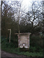
Victorian Spring, Wiston
This spring is along Spithandle Lane.
Image: © Peter Whitcomb
Taken: 13 Dec 2009
0.01 miles
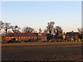
2
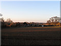
Stocks Field
The name of the field according to Ashington's 1847 tithe map that has been extended to include Image to the north and Image to the north west. The dwellings in the distance are numbers 1-6 Stock's Hill.
Image: © Simon Carey
Taken: 20 Feb 2013
0.03 miles
3
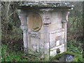
The Lions Mouth Fountain
Located on Spithandle Lane near a group of cottages called Stocks Hill. The fountain is on a spring and is made of sandstone with the eastern side containing a medallion commemorating Queen Victoria's diamond jubilee. For many years the water had stopped flowing from the 'lions mouth' but was fixed at the turn of the century. The sandstone blocks look old and worn and I'm wondering whether the materials are much older. The footpath goes to Waterlane Barn then heads south to the A283.
Image: © Simon Carey
Taken: 20 Apr 2013
0.03 miles
4
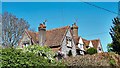
House on Spithandle Lane
This could be a pair of houses, I suppose.
Image: © Ian Hawfinch
Taken: 20 Apr 2020
0.04 miles
5
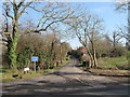
Spithandle Lane
This is the western junction meeting Hole Street and Water Lane of the long meandering lane from Horsebridge Common. The hedgerows have been removed since my last visit, see Image The buildings in the distance are numbers 5-6 Stocks Hill.
Image: © Simon Carey
Taken: 20 Feb 2013
0.05 miles
6
Spithandle Lane
Narrow and winding lane that links Water Lane at Wiston with the B2135 at Horsebridge Common. Taken from the junction with Water Lane.
Image: © Simon Carey
Taken: 2 Oct 2008
0.05 miles
7
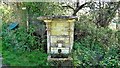
Old fountain on the south side of Spithandle Lane
There are several fountains of this sort located on springs to the north of the Downs. This one is further from the Downs than the others that I am familiar with. (There are a couple near Fulking, for example.)
Image: © Ian Hawfinch
Taken: 20 Apr 2020
0.06 miles
8
Stock's Field
The name of the cottages built after the Second World War that face onto Spithandle Lane. They are named after Image which lies out of shot to the left.
Image: © Simon Carey
Taken: 20 Feb 2013
0.06 miles
9
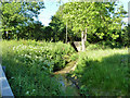
Stream by Water Lane
Fed by springs below the South Downs, the waters eventually reach the sea via the River Adur. The bridge ahead is for Spithandle Lane.
Image: © Robin Webster
Taken: 21 May 2011
0.07 miles
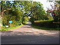
10
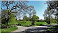
Junction between Hole Street and Spithandle Lane
Image: © Ian Hawfinch
Taken: 20 Apr 2020
0.07 miles