IMAGES TAKEN NEAR TO
Hole Street, STEYNING, BN44 3DH
Introduction
This page details the photographs taken nearby to Hole Street, BN44 3DH by members of the Geograph project.
The Geograph project started in 2005 with the aim of publishing, organising and preserving representative images for every square kilometre of Great Britain, Ireland and the Isle of Man.

There are currently over 7.5m images from over14,400 individuals and you can help contribute to the project by visiting https://www.geograph.org.uk
Image Map
Images are licensed for reuse under creativecommons.org/licenses/by-sa/2.0
Notes
- Clicking on the map will re-center to the selected point.
- The higher the marker number, the further away the image location is from the centre of the postcode.
Image Listing (22 Images Found)
Images are licensed for reuse under creativecommons.org/licenses/by-sa/2.0
Image
Details
Distance
1
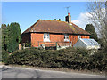
Bramley Cottage, Hole Street
The current building dates back to at least the 19th century and may be a rebuild of something older. The road is also called Hole Street and connects Wiston to Ashington.
Image: © Simon Carey
Taken: 31 Mar 2013
0.01 miles
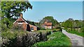
2
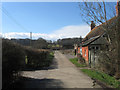
Hole Street Farm
The farmhouse is on the immediate right whilst at the end of the drive is Lower Holestreet Barn. Another barn originally lay on the opposite side of the road but has now been converted into a residence.
Image: © Simon Carey
Taken: 31 Mar 2013
0.04 miles
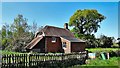
3
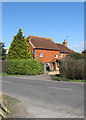
Bennetts, Hole Street
A 16th century house in the hamlet of Hole Street which looks to have been extended northwards at some point in time.
Image: © Simon Carey
Taken: 31 Mar 2013
0.04 miles
4
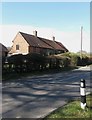
6-6a Hole Street
Lying near the junction of Hole Street and North Lane, the cottages seem to date from the 19th century though it has undergone some rebuilding.
Image: © Simon Carey
Taken: 31 Mar 2013
0.05 miles
5
Sideways, Hole Street
A timber framed house dating from the early 17th century that has indeed been built sideways on from the road.
Image: © Simon Carey
Taken: 31 Mar 2013
0.07 miles
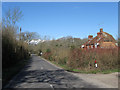
7
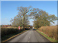
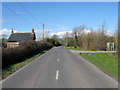
Hole Street
The name of the road between the junction with Spithandle Lane and Kensett's Corner at Ashington. The current road turns left up ahead though the original road continues northwards as a private track called Image The current road is also a bit of a rat run for those wishing to take a short cut from the A24 to Steyning and beyond.
Image: © Simon Carey
Taken: 20 Feb 2013
0.11 miles
9
Trickles Cottages, Hole Street
There are two here divided between East and West and are the last houses on the western side of the hamlet of Hole Street that lie within the old parish boundary of Wiston. The road itself is also called Hole Street and links Wiston to Ashington and is often used as a rat run for those heading south wishing to cut out the Washington Roundabout. The wood beyond is Trickles Wood.
Image: © Simon Carey
Taken: 31 Mar 2013
0.11 miles
10
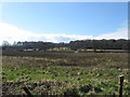
Barn Field
The name of the field according to Wiston's 1841 tithe map viewed from a gap in the hedge on Hole Street. The woods on the slope are Oatash Row Coppice on the right and Lidbetter's Copse to the left.
Image: © Simon Carey
Taken: 31 Mar 2013
0.12 miles