IMAGES TAKEN NEAR TO
St. Julians Lane, SHOREHAM-BY-SEA, BN43 6YS
Introduction
This page details the photographs taken nearby to St. Julians Lane, BN43 6YS by members of the Geograph project.
The Geograph project started in 2005 with the aim of publishing, organising and preserving representative images for every square kilometre of Great Britain, Ireland and the Isle of Man.

There are currently over 7.5m images from over14,400 individuals and you can help contribute to the project by visiting https://www.geograph.org.uk
Image Map
Images are licensed for reuse under creativecommons.org/licenses/by-sa/2.0
Notes
- Clicking on the map will re-center to the selected point.
- The higher the marker number, the further away the image location is from the centre of the postcode.
Image Listing (95 Images Found)
Images are licensed for reuse under creativecommons.org/licenses/by-sa/2.0
Image
Details
Distance
1
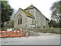
Kingston by Sea, lodge
On Kingston Lane; at the entrance to Shoreham College.
Image: © Mike Faherty
Taken: 7 Apr 2018
0.01 miles
3
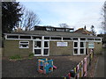
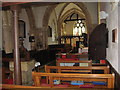
St Julian's Church Hall, Kingston Buci: late February 2016
Image: © Basher Eyre
Taken: 28 Feb 2016
0.02 miles
4
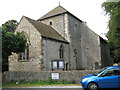
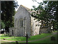
St Julian's Church, Kingston Buci
When the parish & surrounding settlement was founded it was known as "Kingston". By the 14th century the names "Kingston by Shoreham" and "South Kingston" had also been recorded, but in 1315 it took the name "Kingston Bouci" (later "Kingston Buci"), derived from the de Bouci or de Boucey surname of the lord of manor. Later this surname became anglicised to Bowsey and the village name changed accordingly. In the 18th century this was assumed to mean "by sea", and the name "Kingston by Sea" was established. In the 20th century both "Kingston by Sea" and "Kingston Buci" are used.
Today maps refer to it as "Kingston by Sea" and Adur District Council refers to it as "Kingston Buci". The official name of the parish is "St Julian Kingston Buci".
Image: © Josie Campbell
Taken: 6 Aug 2009
0.03 miles
5
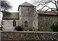
St Julian, Kingston Buci
Another view of the church
Image: © Josie Campbell
Taken: 6 Aug 2009
0.03 miles
7
St. Julian's, Kingston Buci, West Sussex
Image: © nick macneill
Taken: 20 Jan 2012
0.03 miles
8
Kingston by Sea, St. Julian's
Parish church on St. Julian's Lane; dating from C12, with vernacular flint walls. http://www.pastscape.org.uk/hob.aspx?hob_id=398768&sort=2&rational=m&recordsperpage=10&maplat=50.83301932&maplong=-0.24533237&mapisa=1000&mapist=os&mapilo=-0.2453&mapila=50.8330&mapiloe=w&mapilan=n&mapios=TQ235052&mapigrn=105250&mapigre=523550&mapipc=#aRt Footpaths to the church are currently being renovated.
Image: © Mike Faherty
Taken: 7 Apr 2018
0.03 miles
10
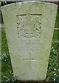
St Julian's Churchyard, Kingston Buci (7)
Also see http://www.cwgc.org/find-war-dead/casualty/402660/WILLIAMS,%20R%20G
Image: © Basher Eyre
Taken: 28 Feb 2016
0.03 miles