IMAGES TAKEN NEAR TO
Tarmount Lane, SHOREHAM-BY-SEA, BN43 6RQ
Introduction
This page details the photographs taken nearby to Tarmount Lane, BN43 6RQ by members of the Geograph project.
The Geograph project started in 2005 with the aim of publishing, organising and preserving representative images for every square kilometre of Great Britain, Ireland and the Isle of Man.

There are currently over 7.5m images from over14,400 individuals and you can help contribute to the project by visiting https://www.geograph.org.uk
Image Map
Images are licensed for reuse under creativecommons.org/licenses/by-sa/2.0
Notes
- Clicking on the map will re-center to the selected point.
- The higher the marker number, the further away the image location is from the centre of the postcode.
Image Listing (519 Images Found)
Images are licensed for reuse under creativecommons.org/licenses/by-sa/2.0
Image
Details
Distance
1
Cottages on Brighton Road and New Road, Shoreham
The one on the right has its entrance on this side, Brighton Road, the one on the left has its front door on the closely parallel and somewhat higher New Road.
Image: © Robin Webster
Taken: 21 Jan 2023
0.03 miles
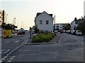
2
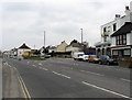
Brighton Road
The A259 entering the central area of New Shoreham. The coast road to Brighton was constructed between 1782-89 and originally entered the town to the right up New Road. The narrowness of that road meant that by the mid 19th century what was originally the Lower Road became the main road into central New Shoreham. The Surry Arms to the right has recently been closed.
Image: © Simon Carey
Taken: 1 Feb 2009
0.03 miles
3
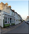
New Road, Shoreham By Sea
Built in the late 18th century as the main road linking Shoreham to Brighton though this section was later replaced by the current route in the mid 19th century.
Image: © Simon Carey
Taken: 24 May 2020
0.04 miles
4
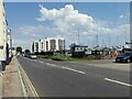
Brighton Road
The A259 Brighton Road follows the Shoreham Harbour.
Image: © James Emmans
Taken: 4 Jun 2022
0.04 miles
5
Brighton Road, Shoreham By Sea
The main A259 is on the left whilst New Road is to the right. The former was built to replace the latter.
Image: © Simon Carey
Taken: 24 May 2020
0.04 miles
7
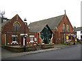
Methodist Church, Brunswick Road, Shoreham-by-Sea
Image: © Stuart Johnson
Taken: 27 Dec 2007
0.05 miles
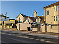
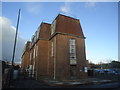
9
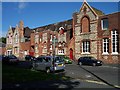
Ham Road Orphanage
I'm told this was Shoreham's orphanage (or possibly workhouse?).
Image: © Bob Embleton
Taken: 1 Oct 2005
0.05 miles
10
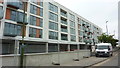
Mariners Point Apartment Development, Shoreham-by-Sea
Image: © Richard Cooke
Taken: 5 Jun 2018
0.05 miles