IMAGES TAKEN NEAR TO
Surry Street, SHOREHAM-BY-SEA, BN43 6RP
Introduction
This page details the photographs taken nearby to Surry Street, BN43 6RP by members of the Geograph project.
The Geograph project started in 2005 with the aim of publishing, organising and preserving representative images for every square kilometre of Great Britain, Ireland and the Isle of Man.

There are currently over 7.5m images from over14,400 individuals and you can help contribute to the project by visiting https://www.geograph.org.uk
Image Map
Images are licensed for reuse under creativecommons.org/licenses/by-sa/2.0
Notes
- Clicking on the map will re-center to the selected point.
- The higher the marker number, the further away the image location is from the centre of the postcode.
Image Listing (432 Images Found)
Images are licensed for reuse under creativecommons.org/licenses/by-sa/2.0
Image
Details
Distance
1
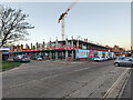
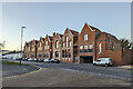
The Mannings redevelopment, Shoreham
In a nod to the town's fishing heritage, 74 flats are being sardined onto a site where 40 were before.
Image: © Robin Webster
Taken: 21 Jan 2023
0.01 miles
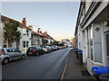
2
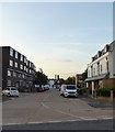
Surry Street, Shoreham By Sea
Residential street linking New Road to Ham Road. Originally laid out in the 19th century all the terraced housing was removed in the late 1950s and the street moved slightly westwards, widened and redeveloped.
Image: © Simon Carey
Taken: 24 May 2020
0.01 miles
3
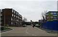
Surry Street
Connecting New Road to Ham Road, Pashley Court is on the right and Mannings the left.
Image: © Simon Carey
Taken: 1 Feb 2009
0.01 miles
4
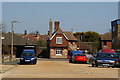
Surry Street, Shoreham, Sussex
Looking down Surry Street, towards an attractive building, which stands on Ham Road. Note the road surface, which is concrete.
Image: © Peter Trimming
Taken: 17 Apr 2010
0.02 miles
5
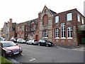
Caxton House
Former school in Ham Road, Shoreham-by-Sea, now occupied by Service Publications Ltd.
Image: © David960
Taken: 13 Aug 2014
0.03 miles
6

Junction of New Road and Brighton Road, Shoreham
Image: © nick macneill
Taken: 20 Jan 2012
0.04 miles
7
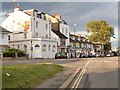
Junction of New Road and Brighton Road, Shoreham-by-Sea
Surry House is the former Surry Arms public house. (Surry is the correct spelling.)
Image: © David960
Taken: 13 Aug 2014
0.04 miles
8
Caxton House, Ham Road, Shoreham
A residential redevelopment of a commercial site, largely if not entirely a demolish and build using design elements of what was there. But leaving out the more interesting design elements - see Image
Image: © Robin Webster
Taken: 21 Jan 2023
0.04 miles
9
Adur Voluntary Action
At the Old School House, Ham Road, Shoreham-by-Sea.
Image: © David960
Taken: 13 Aug 2014
0.04 miles
10
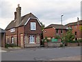
New Road, Shoreham
Dating from around 1820, according to maps, it is older than the parallel A259 Brighton Road closer to the shore.
Image: © Robin Webster
Taken: 21 Jan 2023
0.04 miles