1
Brighton Road
The A259 entering the central area of New Shoreham. The coast road to Brighton was constructed between 1782-89 and originally entered the town to the right up New Road. The narrowness of that road meant that by the mid 19th century what was originally the Lower Road became the main road into central New Shoreham. The Surry Arms to the right has recently been closed.
Image: © Simon Carey
Taken: 1 Feb 2009
0.01 miles
2
Brighton Road, Shoreham By Sea
The main A259 is on the left whilst New Road is to the right. The former was built to replace the latter.
Image: © Simon Carey
Taken: 24 May 2020
0.02 miles
3
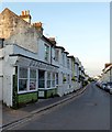
New Road, Shoreham
Dating from around 1820, according to maps, it is older than the parallel A259 Brighton Road closer to the shore.
Image: © Robin Webster
Taken: 21 Jan 2023
0.03 miles
4
Cottages on Brighton Road and New Road, Shoreham
The one on the right has its entrance on this side, Brighton Road, the one on the left has its front door on the closely parallel and somewhat higher New Road.
Image: © Robin Webster
Taken: 21 Jan 2023
0.03 miles
5
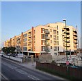
Mariners Point Apartment Development, Shoreham-by-Sea
Image: © Richard Cooke
Taken: 5 Jun 2018
0.03 miles
6
Mariner Point, Brighton Road, Shoreham
Completed in 2018 on the site of a former Royal Mail parcel office.
Image: © Simon Carey
Taken: 24 May 2020
0.04 miles
7
Flats, Shoreham Harbour
Called Mariner Point.
Image: © Robin Webster
Taken: 21 Jan 2023
0.04 miles
8
The Mannings redevelopment, Shoreham
In a nod to the town's fishing heritage, 74 flats are being sardined onto a site where 40 were before.
Image: © Robin Webster
Taken: 21 Jan 2023
0.05 miles
9
Brighton Road
The A259 Brighton Road follows the Shoreham Harbour.
Image: © James Emmans
Taken: 4 Jun 2022
0.05 miles
10
New Road, Shoreham By Sea
Built in the late 18th century as the main road linking Shoreham to Brighton though this section was later replaced by the current route in the mid 19th century.
Image: © Simon Carey
Taken: 24 May 2020
0.05 miles


