IMAGES TAKEN NEAR TO
Orchard Close, SHOREHAM-BY-SEA, BN43 5UT
Introduction
This page details the photographs taken nearby to Orchard Close, BN43 5UT by members of the Geograph project.
The Geograph project started in 2005 with the aim of publishing, organising and preserving representative images for every square kilometre of Great Britain, Ireland and the Isle of Man.

There are currently over 7.5m images from over14,400 individuals and you can help contribute to the project by visiting https://www.geograph.org.uk
Image Map
Images are licensed for reuse under creativecommons.org/licenses/by-sa/2.0
Notes
- Clicking on the map will re-center to the selected point.
- The higher the marker number, the further away the image location is from the centre of the postcode.
Image Listing (82 Images Found)
Images are licensed for reuse under creativecommons.org/licenses/by-sa/2.0
Image
Details
Distance
1
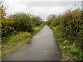
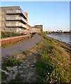
Regional Cycle Route 79
Part of new extension to Downs Link bridleway linking the route with the Adur riverside path and Shoreham's new Ropetackle development.
Image: © Peter Holmes
Taken: 8 Nov 2008
0.07 miles
2
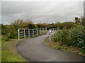
New construction on Regional Cycle Route 79
Thanks to a grant from the South East England Development Agency, Sustrans created this new link from the end of the Downs Link bridleway to the Adur riverside path. This involved filling in a deep ditch and building a new section of the path with safety railings.
Image: © Peter Holmes
Taken: 8 Nov 2008
0.08 miles
3

Cormorant House, Shoreham By Sea
Part of the new Waterside Development located to the north of the railway bridge. The old buffers in the foreground are a reminder of the former Shoreham-Christ's Hospital branch railway that operated here from 1861-1966 and is now the Downslink.
Image: © Simon Carey
Taken: 25 May 2020
0.09 miles
4

Dismantled railway beside River Adur
On the Downs Link path leading north of Shoreham
Image: © Paul Gillett
Taken: 16 May 2010
0.09 miles
5
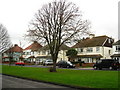
Connaught Avenue, Shoreham-by-Sea
Suburban inter-War housing
Image: © Stuart Johnson
Taken: 27 Dec 2007
0.09 miles
6
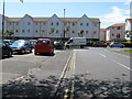
New housing on Old Shoreham Road, Shoreham
Opposite the car park for the Swiss Cottage.
Image: © Dave Spicer
Taken: 5 Jul 2012
0.09 miles
7
River Walk Way
New waterside footpath providing a link between the Downslink and the Ropetackle development running alongside the new Waterfront Development.
Image: © Simon Carey
Taken: 25 May 2020
0.09 miles
8
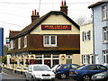
Swiss Cottage pub, Old Shoreham Rd, Shoreham-by-Sea
Image: © Stuart Johnson
Taken: 27 Dec 2007
0.10 miles
9
Railway Buffers, Downs Link
The rear view of this, Image where the vegetation has now been cleared after the extension of the Downs Link path was built between the old Toll Bridge and the Ropetackle development. The Horsham-Shoreham line opened in 1861 and was closed in 1966 except for a small section between Shoreham and Beeding Cement Works that remained open until 1981.
Image: © Simon Carey
Taken: 7 Dec 2008
0.10 miles
