IMAGES TAKEN NEAR TO
Riverside Road, SHOREHAM-BY-SEA, BN43 5RB
Introduction
This page details the photographs taken nearby to Riverside Road, BN43 5RB by members of the Geograph project.
The Geograph project started in 2005 with the aim of publishing, organising and preserving representative images for every square kilometre of Great Britain, Ireland and the Isle of Man.

There are currently over 7.5m images from over14,400 individuals and you can help contribute to the project by visiting https://www.geograph.org.uk
Image Map
Images are licensed for reuse under creativecommons.org/licenses/by-sa/2.0
Notes
- Clicking on the map will re-center to the selected point.
- The higher the marker number, the further away the image location is from the centre of the postcode.
Image Listing (267 Images Found)
Images are licensed for reuse under creativecommons.org/licenses/by-sa/2.0
Image
Details
Distance
1
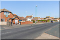
Riverside Road
Looking along Riverside Road, a road first shown (largely undeveloped) on the 1937 25" map.
Image: © Ian Capper
Taken: 17 Mar 2022
0.05 miles
2
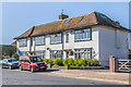
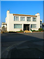
Tudor Mansions
Block of four maisonettes at 11 & 13 Riverside Road. First shown in outline on the 1949 6" map, the name suggests that the building was contemporaneous with the nearby Tudor House (now the Waterside - see Image) built in the late 1930s but also shown in outline only on the same map.
Image: © Ian Capper
Taken: 17 Mar 2022
0.05 miles
3
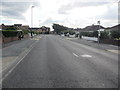
Bus Stop, Riverside Road
Compass bus stop for service 19 to Holmbush Centre, Shoreham.
Image: © Peter Holmes
Taken: 31 Aug 2013
0.05 miles
4
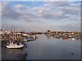
River Adur from Shoreham Footbridge
Looking seaward towards Shoreham Harbour. Sussex Yacht Club have premises on the left.
Image: © Bob Embleton
Taken: 31 May 2006
0.06 miles
5
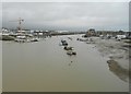
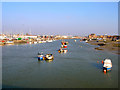
River Adur at Shoreham-by-Sea (2)
This is the view looking downstream along the West Arm of the river from the dead centre of Image
Image: © Nigel Cox
Taken: 5 Feb 2016
0.06 miles
6
Shoreham Harbour (River Adur) - Shoreham Beach side
Looking downriver from the swing footbridge.
Image: © Robin Webster
Taken: 21 Jan 2023
0.07 miles
7
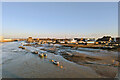
Pelican and Otia Margaretta
Two of the three houseboats located near to Lower Beach Road, Pelican is to the right, Otia Margaretta is on the left. A third Guidance, is out of shot to the right. They are the last reminder of the original Edwardian Bohemian lifestyle of the area, much of which was cleared during World War Two with only the houseboats remaining. Even then they faced long periods of conflict with the local council before the latter grudgingly accepted their existence. Viewed from the mud at low tide.
Image: © Simon Carey
Taken: 29 Mar 2009
0.08 miles
8
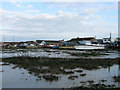
River Adur
Viewed from underneath the Adur Ferry Bridge.
Image: © Simon Carey
Taken: 25 May 2020
0.08 miles
9
Doveleys Court, Riverside Road
Small block of flats backing onto the river.
Image: © Simon Carey
Taken: 15 Feb 2008
0.08 miles
10
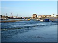
River Adur
Looking eastwards from the drawbridge. Sussex Yacht Club is to the left whilst in the distance is the Emerald Quay development built on the site of a former timber wharf.
Image: © Simon Carey
Taken: 15 Feb 2008
0.08 miles