IMAGES TAKEN NEAR TO
Steyning Road, SHOREHAM-BY-SEA, BN43 5NG
Introduction
This page details the photographs taken nearby to Steyning Road, BN43 5NG by members of the Geograph project.
The Geograph project started in 2005 with the aim of publishing, organising and preserving representative images for every square kilometre of Great Britain, Ireland and the Isle of Man.

There are currently over 7.5m images from over14,400 individuals and you can help contribute to the project by visiting https://www.geograph.org.uk
Image Map
Images are licensed for reuse under creativecommons.org/licenses/by-sa/2.0
Notes
- Clicking on the map will re-center to the selected point.
- The higher the marker number, the further away the image location is from the centre of the postcode.
Image Listing (246 Images Found)
Images are licensed for reuse under creativecommons.org/licenses/by-sa/2.0
Image
Details
Distance
1
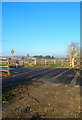
Old Level Crossing
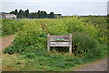
The former Shoreham-Horsham railway crosses the former A27. The railway opened in 1861 and closed in 1966 whilst the road opened in 1782 and was closed to traffic in 1970. Both are now cycle paths and footpaths.
Image: © Simon Carey
Taken: 7 Dec 2008
0.02 miles
2
The Downs Link at Shoreham
The Downs Link is a long distance path that follows the disused railway line from the coast at Shoreham to Guildford. This view is looking inland along the path of the old railway line at a point were it was crossed by the A27, which carried road traffic between Brighton and Worthing.(Now also a foot path) There was a level crossing at this point with the signal box positioned on the far right of the junction.
Image: © Peter Jeffery
Taken: 25 Jul 2020
0.02 miles
3
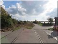
Cyclepath at Old Shoreham (Junction with Toll Bridge)
It shows the remains of the old railway track where the level crossing was
Image: © Andy Horton
Taken: 22 Oct 2016
0.02 miles
4
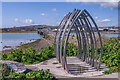
Shoreham Airshow Memorial
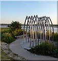
Memorial to the 11 men killed in the 22 August 2015 Shoreham Airshow tragedy by where the Downs Link cycle/foot trail passes the Old Shoreham Bridge across the River Adur. Designed by local artists Jane Fordham and David Parfitt and unveiled in May 2019, each of the 11 arches represent one of those who died.
Image: © Ian Capper
Taken: 17 Mar 2022
0.02 miles
6
Memorial, Shoreham Airshow Crash
Located next to the Old Toll Bridge where many tributes were left in the wake of the 2015 disaster. Each metal rail represents one of the 11 men killed when a Hawker Hunter failed to complete a loop and crashed into the A27.
Image: © Simon Carey
Taken: 25 May 2020
0.02 miles
7
Old shoreham Toll Bridge
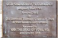
Information plaque on the Old Shoreham Toll Bridge, detailing it's restoration in 2008.
Image: © Peter Jeffery
Taken: 17 Jul 2020
0.02 miles
8
Cyclists at Shoreham
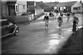
Members of the Brighton and District Section of the Cyclists Touring Club, about to leave for a days ride. They have met at the end of St. Nicolas Lane, adjacent to the Red Lion, and are about to head west across the A283, and to pay their fees for access to the Old Shoreham Toll Bridge.
Image: © Peter Jeffery
Taken: Unknown
0.03 miles
9
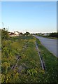
Old Rails, Downslink
When the sea defences were rebuilt in 2016-17 and the Downslink upgraded the former rails that still remained in the ground were moved a little to the south, see Image The long distance path follows the course of the former Shoreham to Christ's Hospital railway that was opened in 1861 and closed in 1966.
Image: © Simon Carey
Taken: 25 May 2020
0.03 miles
10
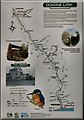
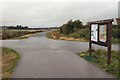
Downs Link
An illustrated map of the long-distance path on display at its southern end, adjacent to the Old Shoreham Toll Bridge.
Image: © Peter Jeffery
Taken: 25 Jul 2020
0.03 miles