IMAGES TAKEN NEAR TO
Emerald Quay, SHOREHAM-BY-SEA, BN43 5JY
Introduction
This page details the photographs taken nearby to Emerald Quay, BN43 5JY by members of the Geograph project.
The Geograph project started in 2005 with the aim of publishing, organising and preserving representative images for every square kilometre of Great Britain, Ireland and the Isle of Man.

There are currently over 7.5m images from over14,400 individuals and you can help contribute to the project by visiting https://www.geograph.org.uk
Image Map
Images are licensed for reuse under creativecommons.org/licenses/by-sa/2.0
Notes
- Clicking on the map will re-center to the selected point.
- The higher the marker number, the further away the image location is from the centre of the postcode.
Image Listing (143 Images Found)
Images are licensed for reuse under creativecommons.org/licenses/by-sa/2.0
Image
Details
Distance
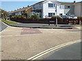
1
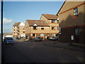
Flats by the waterside
near Shoreham Harbour, Shoreham Beach,
Image: © Paul Gillett
Taken: 6 Dec 2009
0.01 miles
2
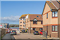
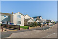
West Point, Sussex Court & North Point
Three apartment blocks on Emerald Quay, off Riverside Road, built in 1996-7.
Image: © Ian Capper
Taken: 17 Mar 2022
0.02 miles
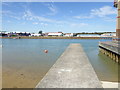
3
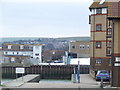
Emerald Quay, Shoreham Beach
A view across the River Adur from Shoreham Beach, over to Shoreham. In the foreground is a slipway down to the river. In the background are the South Downs. On the opposite bank of the river is a short road called Humphrey's Gap - have a look at image Image for a view from Humphrey's Gap looking towards Shoreham Beach.
Image: © Malc McDonald
Taken: 5 Mar 2011
0.02 miles
4
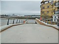
Shoreham Harbour, slipway
A private slipway, for residents of Image
Image: © Mike Faherty
Taken: 7 Apr 2018
0.04 miles
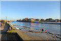
5

Slipway by Emerald Quay
Emerald Quay is a luxury development on the bank of the River Adur.
Image: © Dave Spicer
Taken: 14 Nov 2012
0.04 miles
7
Looking along wall by slipway into the Adur
See also http://www.geograph.org.uk/photo/1233310 from 2009.
Image: © Shazz
Taken: 7 Sep 2016
0.05 miles
8
Shoreham Harbour (River Adur)
Looking towards the open sea.
Image: © Robin Webster
Taken: 21 Jan 2023
0.05 miles
9
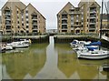
Shoreham Harbour, Emerald Quay
An inlet off the harbour; now residential, with private moorings.
Image: © Mike Faherty
Taken: 7 Apr 2018
0.05 miles
10
Shingle Road
Houses in Shingle Road. The road is first shown (largely undeveloped) on the 1937 25" map, but the 1912 edition shows a tramway along the line it now follows.
Image: © Ian Capper
Taken: 17 Mar 2022
0.06 miles