IMAGES TAKEN NEAR TO
The Avenue, SHOREHAM-BY-SEA, BN43 5GJ
Introduction
This page details the photographs taken nearby to The Avenue, BN43 5GJ by members of the Geograph project.
The Geograph project started in 2005 with the aim of publishing, organising and preserving representative images for every square kilometre of Great Britain, Ireland and the Isle of Man.

There are currently over 7.5m images from over14,400 individuals and you can help contribute to the project by visiting https://www.geograph.org.uk
Image Map
Images are licensed for reuse under creativecommons.org/licenses/by-sa/2.0
Notes
- Clicking on the map will re-center to the selected point.
- The higher the marker number, the further away the image location is from the centre of the postcode.
Image Listing (8 Images Found)
Images are licensed for reuse under creativecommons.org/licenses/by-sa/2.0
Image
Details
Distance
1
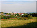
Mill Hill, Shoreham
Taken from the road just beyond the bridge over the main A27 trunk road, the view looks south west through the Mill Hill estate and follows the square to its edge roughly before the first small set of chimneys at Southland Hospital. To the right is the even bigger chimney of Shoreham power station and beyond that is the sea. On the left hand side is a faint view of Brighton, 6 miles away. The large block of flats just visible is Sussex Heights.
Image: © Simon Carey
Taken: 2 Sep 2005
0.23 miles
2
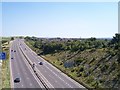
A27 through Mill Hill
Looking East towards Slonk Hill. The single tower of Shoreham power station can be seen on the right of the picture.
Image: © Bob Embleton
Taken: 29 Aug 2005
0.23 miles
3
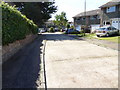
Chanctonbury Drive
Houses being built by Wimpey's in 1975. Ready for occupation end of September.
Image: © Josie Campbell
Taken: Unknown
0.23 miles
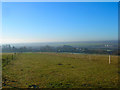
6

Mill Hill grazing land
This large field has been split up into a several paddocks for grazing horses.
The buildings of Shoreham airport can be seen in the distance.
Image: © Peter Holmes
Taken: 8 Nov 2008
0.24 miles
7
Fields Behind Old Shoreham
Viewed from the footpath that links Mill Hill to the A283. The fields back out from the old main street of Old Shoreham. The River Adur, Old Toll Bridge and Shoreham Airport can be viewed through the haze to the right.
Image: © Simon Carey
Taken: 7 Dec 2008
0.24 miles