IMAGES TAKEN NEAR TO
Town Quay, SHOREHAM-BY-SEA, BN43 5DS
Introduction
This page details the photographs taken nearby to Town Quay, BN43 5DS by members of the Geograph project.
The Geograph project started in 2005 with the aim of publishing, organising and preserving representative images for every square kilometre of Great Britain, Ireland and the Isle of Man.

There are currently over 7.5m images from over14,400 individuals and you can help contribute to the project by visiting https://www.geograph.org.uk
Image Map
Images are licensed for reuse under creativecommons.org/licenses/by-sa/2.0
Notes
- Clicking on the map will re-center to the selected point.
- The higher the marker number, the further away the image location is from the centre of the postcode.
Image Listing (573 Images Found)
Images are licensed for reuse under creativecommons.org/licenses/by-sa/2.0
Image
Details
Distance
1
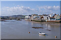
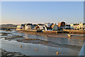
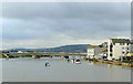
River Adur
Looking up the River Adur, with buildings in High Street on the right.
Image: © Ian Capper
Taken: 17 Mar 2022
0.00 miles
2
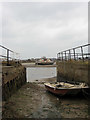
Ship Street Hard
Public slipway on the south side of the High Street. The boat across the river is Image
Image: © Simon Carey
Taken: 1 Feb 2009
0.01 miles
3
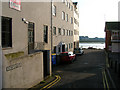
Town Quay
Next to the former Town Hall which originally was built as a custom house in 1830 and is now a Pressos restaurant and bar.
Image: © Simon Carey
Taken: 15 Feb 2008
0.01 miles
4
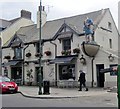
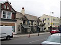
Crown and Anchor, Shoreham-by-Sea
There is a Francis Frith photo of this pub dated 1950 https://www.francisfrith.com/shoreham-by-sea/shoreham-by-sea-crown-and-anchor-hotel-c1950_s123019 and it looks just the same, but I have not been able to find any further information about it. It is on Brighton Road, opposite the Marlipins Museum.
Image: © Tricia Neal
Taken: 13 Aug 2013
0.01 miles
5
River Adur, Shoreham
Between the Adur Ferry Bridge and Norfolk Bridge (A259).
Image: © Robin Webster
Taken: 21 Jan 2023
0.02 miles
6
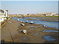
Shoreham at low tide
View towards the footbridge from Norfolk Bridge (the whistling bridge as it is known locally, when the wind blows)
Image: © Bob Parkes
Taken: 28 Jul 2006
0.02 miles
7
Crown and Anchor, High Street Shoreham-by-Sea
Image: © PAUL FARMER
Taken: 20 Sep 2011
0.02 miles
8
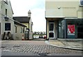
Twitten, Shoreham-by-Sea
'Twitten' is the Sussex term for an alleyway.
Image: © nick macneill
Taken: 17 May 2013
0.02 miles
9
River Adur at Shoreham-by-Sea, West Sussex
Looking west-north-west from the footbridge towards the A259 coast road crossing Norfolk Bridge. Worthing is to the left, with Brighton (and inland Old Shoreham) to the right. The South Downs form the skyline.
Image: © Roger D Kidd
Taken: 31 Dec 2009
0.02 miles
10
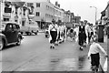
Morris Dancers parade through Shoreham
Members of the Chanctonbury Morris Dancers parade through Shoreham on May Day, between performing at various locations within the town.
Image: © Peter Jeffery
Taken: 1 May 1965
0.02 miles