IMAGES TAKEN NEAR TO
Ravens Road, SHOREHAM-BY-SEA, BN43 5AX
Introduction
This page details the photographs taken nearby to Ravens Road, BN43 5AX by members of the Geograph project.
The Geograph project started in 2005 with the aim of publishing, organising and preserving representative images for every square kilometre of Great Britain, Ireland and the Isle of Man.

There are currently over 7.5m images from over14,400 individuals and you can help contribute to the project by visiting https://www.geograph.org.uk
Image Map
Images are licensed for reuse under creativecommons.org/licenses/by-sa/2.0
Notes
- Clicking on the map will re-center to the selected point.
- The higher the marker number, the further away the image location is from the centre of the postcode.
Image Listing (319 Images Found)
Images are licensed for reuse under creativecommons.org/licenses/by-sa/2.0
Image
Details
Distance
1
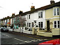
Ravens Road, Shoreham-by-Sea
Interestingly coloured housing
Image: © Stuart Johnson
Taken: 27 Dec 2007
0.05 miles
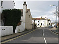
2
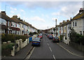
Queens Place
Linking Buckingham Road with Mill Lane. Built in the 1860s after the arrival of the railway.
Image: © Simon Carey
Taken: 1 Feb 2009
0.07 miles
3
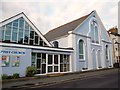
Shoreham Baptist Church
In Western Road, Shoreham-by-Sea.
Image: © David960
Taken: 13 Aug 2014
0.07 miles
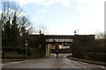
5
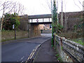
Railway bridge BLI1 448, Southdown Road, Shoreham
Headroom 13'-0". No metric figure, so only Americans and old British people can use it.
Image: © Robin Webster
Taken: 21 Jan 2023
0.08 miles
6
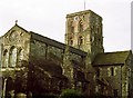
Shoreham Church
Norman Church in the newly laid out port of Shoreham abandoning Old Shoreham further up the river.
Image: © Bob Embleton
Taken: Unknown
0.08 miles
7
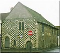
Marlipins
Possibly a Norman chapel - now a museum. The High Street front is mainly arranged in a chequer of squares, alternately of Caen stone and flint.
Image: © Bob Embleton
Taken: Unknown
0.08 miles
8
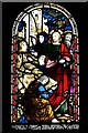
Shoreham-by-Sea, St. Mary de Haura Church: Stained glass window
Image: © Michael Garlick
Taken: 3 Aug 2019
0.08 miles
9
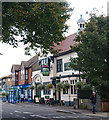
"The Crab Tree" public house, Shoreham-by-Sea
Image: © Jim Osley
Taken: 7 Oct 2016
0.09 miles
10
Mill Lane
Linking Buckingham Road with Upper Shoreham Road and built along the former country lane that lead to the windmill on Mill Hill. The junction with Queens Place can be seen in the distance.
Image: © Simon Carey
Taken: 1 Feb 2009
0.10 miles