IMAGES TAKEN NEAR TO
Ravens Road, SHOREHAM-BY-SEA, BN43 5AW
Introduction
This page details the photographs taken nearby to Ravens Road, BN43 5AW by members of the Geograph project.
The Geograph project started in 2005 with the aim of publishing, organising and preserving representative images for every square kilometre of Great Britain, Ireland and the Isle of Man.

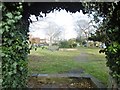
There are currently over 7.5m images from over14,400 individuals and you can help contribute to the project by visiting https://www.geograph.org.uk
Image Map
Images are licensed for reuse under creativecommons.org/licenses/by-sa/2.0
Notes
- Clicking on the map will re-center to the selected point.
- The higher the marker number, the further away the image location is from the centre of the postcode.
Image Listing (268 Images Found)
Images are licensed for reuse under creativecommons.org/licenses/by-sa/2.0
Image
Details
Distance
1
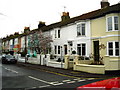
Ravens Road, Shoreham-by-Sea
Interestingly coloured housing
Image: © Stuart Johnson
Taken: 27 Dec 2007
0.03 miles
2
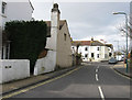
Mill Lane
Linking Buckingham Road with Upper Shoreham Road and built along the former country lane that lead to the windmill on Mill Hill. The junction with Queens Place can be seen in the distance.
Image: © Simon Carey
Taken: 1 Feb 2009
0.04 miles
3
Queens Place
Linking Buckingham Road with Mill Lane. Built in the 1860s after the arrival of the railway.
Image: © Simon Carey
Taken: 1 Feb 2009
0.04 miles
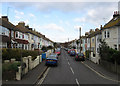
4
Buckingham Road
Beginning north of the level crossing and heading north to Upper Shoreham Road, the former A27. The older Victorian houses give way to more modern development beyond this point.
Image: © Simon Carey
Taken: 1 Feb 2009
0.07 miles
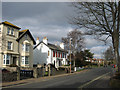
5
Shoreham-by-Sea, gardens
Windlesham Gardens, an open space between arms of the road with the same name.
Image: © Mike Faherty
Taken: 9 Dec 2017
0.08 miles
6
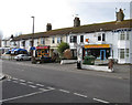
Shops, Buckingham Road
Opposite Image and seem to include the typical fare for commuters, a florist (for those late arrivals when the trains delayed), a newsagent, and two take aways.
Image: © Simon Carey
Taken: 1 Feb 2009
0.09 miles
7
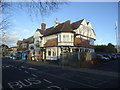
The Crab Tree public house, Shoreham-by-Sea
Image: © Stacey Harris
Taken: 17 Dec 2011
0.10 miles
8
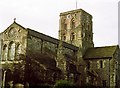
Shoreham Church
Norman Church in the newly laid out port of Shoreham abandoning Old Shoreham further up the river.
Image: © Bob Embleton
Taken: Unknown
0.10 miles
9
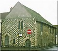
Marlipins
Possibly a Norman chapel - now a museum. The High Street front is mainly arranged in a chequer of squares, alternately of Caen stone and flint.
Image: © Bob Embleton
Taken: Unknown
0.10 miles
10
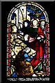
Shoreham-by-Sea, St. Mary de Haura Church: Stained glass window
Image: © Michael Garlick
Taken: 3 Aug 2019
0.10 miles