IMAGES TAKEN NEAR TO
BN42 4JE
Introduction
This page details the photographs taken nearby to BN42 4JE by members of the Geograph project.
The Geograph project started in 2005 with the aim of publishing, organising and preserving representative images for every square kilometre of Great Britain, Ireland and the Isle of Man.

There are currently over 7.5m images from over14,400 individuals and you can help contribute to the project by visiting https://www.geograph.org.uk
Image Map
Images are licensed for reuse under creativecommons.org/licenses/by-sa/2.0
Notes
- Clicking on the map will re-center to the selected point.
- The higher the marker number, the further away the image location is from the centre of the postcode.
Image Listing (144 Images Found)
Images are licensed for reuse under creativecommons.org/licenses/by-sa/2.0
Image
Details
Distance
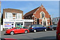
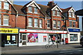
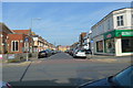
3
Station & Boundary Road
Somewhere up the middle of road lies the parish boundary between Portslade and Hove.Subsequently, with two councils owning the street it has two names. The western, Portslade side (left) is called Station Road, the eastern, Hove side (right) is called Boundary Road. Now the B2194 it is the main shopping street for the Portslade and Aldrington area.
Image: © Simon Carey
Taken: 9 Dec 2007
0.02 miles
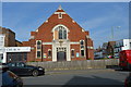
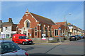
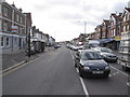
5
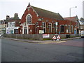
Portslade United Reformed Church
At junction of Station Road (B2194) and St Aubyn's Road.
Image: © Peter Holmes
Taken: 17 Mar 2012
0.03 miles