IMAGES TAKEN NEAR TO
Phoenix Way, BRIGHTON, BN42 4HP
Introduction
This page details the photographs taken nearby to Phoenix Way, BN42 4HP by members of the Geograph project.
The Geograph project started in 2005 with the aim of publishing, organising and preserving representative images for every square kilometre of Great Britain, Ireland and the Isle of Man.

There are currently over 7.5m images from over14,400 individuals and you can help contribute to the project by visiting https://www.geograph.org.uk
Image Map (Loading...)


Getting Data...Please wait
Leaflet Map data © OpenStreetMap
Images are licensed for reuse under creativecommons.org/licenses/by-sa/2.0
Notes
- Clicking on the map will re-center to the selected point.
- The higher the marker number, the further away the image location is from the centre of the postcode.
Image Listing (23 Images Found)
Images are licensed for reuse under creativecommons.org/licenses/by-sa/2.0
Image
Details
Distance
1
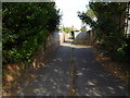
Twitten opposite side of Kingston Lane from Clarendon Road
Image: © Shazz
Taken: 29 Aug 2016
0.07 miles
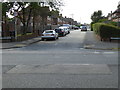
3
Oldfield Crescent
1930s housing off Church Lane.
Image: © Ian Capper
Taken: 21 Jan 2022
0.18 miles
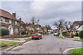
4
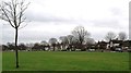
The Green
Name of the B2167 as it skirts the eastern side of open space also known as The Green before splitting into two at the crossroads, Cross Road to the west and Southview Road to the north both heading towards the Old Shoreham Road, the A270.
Image: © Simon Carey
Taken: 2 Dec 2010
0.19 miles
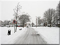
5
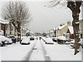
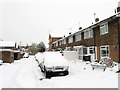
Southview Road
Laid out in the 1890s and developed in the first decade of the 20th century. The B2167 links the northern end of The Green with Old Shoreham Road, the A270. After 8-10 inches of snow fell overnight there is little traffic except the use of feet.
Image: © Simon Carey
Taken: 2 Dec 2010
0.19 miles
8
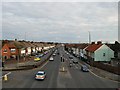
Old Shoreham Road
Viewed from the Footbridge at Kingston Image
Image: © Paul Gillett
Taken: 24 Jan 2010
0.21 miles
9
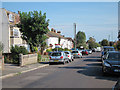
Southview Close
Small cul-de-sac off Southview Road built in the 1950s.
Image: © Simon Carey
Taken: 2 Dec 2010
0.21 miles
10
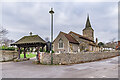
Church of St Michael and All Angels
Largely built in the 12th/13th Centuries, with major rebuilding in the 19th and 20th Centuries, the latter in the late 1940s due to an unexpolded bomb Grade II* listed - see https://historicengland.org.uk/listing/the-list/list-entry/1353751?section=official-listing. The lychgate dates from 1908.
Image: © Ian Capper
Taken: 21 Jan 2022
0.21 miles