IMAGES TAKEN NEAR TO
The Green, BRIGHTON, BN42 4FX
Introduction
This page details the photographs taken nearby to The Green, BN42 4FX by members of the Geograph project.
The Geograph project started in 2005 with the aim of publishing, organising and preserving representative images for every square kilometre of Great Britain, Ireland and the Isle of Man.

There are currently over 7.5m images from over14,400 individuals and you can help contribute to the project by visiting https://www.geograph.org.uk
Image Map (Loading...)


Getting Data...Please wait
Leaflet Map data © OpenStreetMap
Images are licensed for reuse under creativecommons.org/licenses/by-sa/2.0
Notes
- Clicking on the map will re-center to the selected point.
- The higher the marker number, the further away the image location is from the centre of the postcode.
Image Listing (69 Images Found)
Images are licensed for reuse under creativecommons.org/licenses/by-sa/2.0
Image
Details
Distance
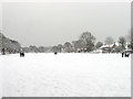
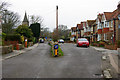
1
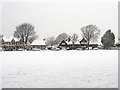
The Green
The former common for Southwick was purchased by the local council in 1903 for use as a recreational space.
Image: © Simon Carey
Taken: 2 Dec 2010
0.01 miles
3
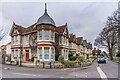
57 The Green
Late 19th Century house on the corner of Church Lane and The Green, with a turret adding interest compared with the rest of the row.
Image: © Ian Capper
Taken: 21 Jan 2022
0.04 miles
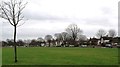
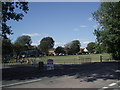
4
The Green
The name of the open space in the centre of Southwick that was once common land before the local council purchased it in 1903 for use as a recreational area. This looks from the very northern tip of the green.
Image: © Simon Carey
Taken: 2 Dec 2010
0.04 miles
5
Church Lane - dual carriageway
An unusual dual carriageway, split by an old flint wall. It appears that the original lane was on the left, and the right one was added later, remarkably preserving the wall.
Image: © Robin Webster
Taken: 23 Mar 2010
0.05 miles
7
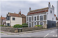
Ivy Lodge
Mid 18th Century house on the corner of Church Lane and The Green, numbered 55 The Green. Grade II listed - see https://historicengland.org.uk/listing/the-list/list-entry/1193356?section=official-listing.
Image: © Ian Capper
Taken: 21 Jan 2022
0.05 miles
8
Church Lane
1930s housing in Church Lane.
Image: © Ian Capper
Taken: 21 Jan 2022
0.06 miles
9
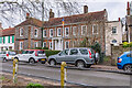
The Hall
Early 18th Century house at 47 - 51 The Green. Grade II* listed - see https://historicengland.org.uk/listing/the-list/list-entry/1027852?section=official-listing.
Blue plaques either side of the porch read (on the left) "Novelist Travel Writer S P B Mais 1885-1975 Fought for cricket on this green Lived here 1927-1932" and (on the right) "Portrait Landscape Genre Painter Douglas Stannus Gray 1890-1959 Lived here 1939-1959.
Image: © Ian Capper
Taken: 21 Jan 2022
0.07 miles
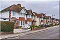
10

34 - 44 The Green
Group of Edwardian semi-detached villas overlooking The Green.
Image: © Ian Capper
Taken: 21 Jan 2022
0.07 miles