IMAGES TAKEN NEAR TO
Albion Street, BRIGHTON, BN42 4ED
Introduction
This page details the photographs taken nearby to Albion Street, BN42 4ED by members of the Geograph project.
The Geograph project started in 2005 with the aim of publishing, organising and preserving representative images for every square kilometre of Great Britain, Ireland and the Isle of Man.

There are currently over 7.5m images from over14,400 individuals and you can help contribute to the project by visiting https://www.geograph.org.uk
Image Map
Images are licensed for reuse under creativecommons.org/licenses/by-sa/2.0
Notes
- Clicking on the map will re-center to the selected point.
- The higher the marker number, the further away the image location is from the centre of the postcode.
Image Listing (223 Images Found)
Images are licensed for reuse under creativecommons.org/licenses/by-sa/2.0
Image
Details
Distance
1
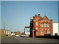
The A259 at Southwick
The brick building to the right is Southwick Old Town Hall.
Image: © nick macneill
Taken: 2 Aug 2012
0.01 miles
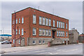
2
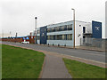
Nautilus House, Albion Street
The front wall and the road are in this square, the rest of the building is in TQ2404. Officially opened in October 2008 after extensive refurbishment as the headquarters for Shoreham Port Authority having acquired the building in 2007 from the previous owners, HM Customs and Excise.
Image: © Simon Carey
Taken: 1 Feb 2009
0.01 miles
3
Southwick, Nautilus House
Headquarters of Shoreham Port Authority, on Albion Street. http://www.shoreham-port.co.uk/History
Image: © Mike Faherty
Taken: 7 Apr 2018
0.01 miles
4
Albion Street
A259 coastal road towards Brighton.
Image: © Oast House Archive
Taken: 1 Sep 2011
0.02 miles
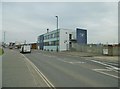
5

Shoreham Harbour
Offices of aggregates group Dudman alongside Shoreham Harbour.
Image: © Ian Capper
Taken: 21 Jan 2022
0.03 miles
6
Albion Wharf
Offices of aggregates group Dudman on Albion Street, alongside Shoreham Harbour.
Image: © Ian Capper
Taken: 21 Jan 2022
0.03 miles

8
Turberville Wharf
Home to Dudmans aggregates firm. The wharf stretches from the lock gates to the small beach next to the lighthouse.
Image: © Simon Carey
Taken: 8 Jul 2007
0.04 miles
9
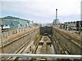
Southwick, dry dock
Adur Dry Dock, on Shoreham Harbour; currently empty. A plaque dates it to 1934. https://www.shoreham-port.co.uk/Dry-Dock
Image: © Mike Faherty
Taken: 11 Aug 2018
0.04 miles
10
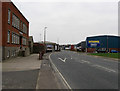
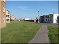
Albion Street
The name of the A259 as it travels through the parish of Southwick. The road first came into existence during the 1780s as an alternative to the older Old Shoreham Road, the current A270, and was turnpiked in 1822. Originally the major commercial hub of the town many of the shops and terraced houses disappeared from the street in the late 1950s when Southwick Square was built north of the railway line. The road is now lifeless containing warehouses on one side and featureless flats built back from the road on the other.
Image: © Simon Carey
Taken: 1 Feb 2009
0.04 miles