IMAGES TAKEN NEAR TO
Twitten Close, BRIGHTON, BN42 4DY
Introduction
This page details the photographs taken nearby to Twitten Close, BN42 4DY by members of the Geograph project.
The Geograph project started in 2005 with the aim of publishing, organising and preserving representative images for every square kilometre of Great Britain, Ireland and the Isle of Man.

There are currently over 7.5m images from over14,400 individuals and you can help contribute to the project by visiting https://www.geograph.org.uk
Image Map
Images are licensed for reuse under creativecommons.org/licenses/by-sa/2.0
Notes
- Clicking on the map will re-center to the selected point.
- The higher the marker number, the further away the image location is from the centre of the postcode.
Image Listing (172 Images Found)
Images are licensed for reuse under creativecommons.org/licenses/by-sa/2.0
Image
Details
Distance
1
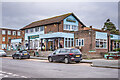
The Cricketers
Pub at the corner of Southwick Square and The Green, replacing a previous pub of the same name (although originally the Cricketers' Arms) when the area was redeveloped in 1958-61 to form a new centre for Southwick.
Image: © Ian Capper
Taken: 21 Jan 2022
0.05 miles
2
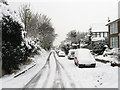
Watling Road
What looks like a side road is actually the B2167 as it leaves Station Road running next to the railway line before ending at the southern most point of The Green.
Image: © Simon Carey
Taken: 2 Dec 2010
0.05 miles
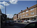
3
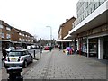
Southwick Street, Southwick
The shop to the right of the photo used to be a Woolworths and has now been converted into an Oriental food supermarket.
Image: © nick macneill
Taken: 20 Jan 2012
0.06 miles
6
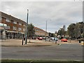
Southwick Square
The square was built in 1960, previously the main shopping area for Southwick was in Albion Street
Image: © Paul Gillett
Taken: 17 Sep 2011
0.07 miles
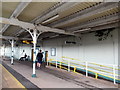
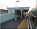
8
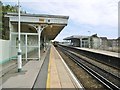
Southwick Station
Offering services between Southampton, Portsmouth and Brighton. A Southern e.m.u. has just left for Brighton.
Image: © Mike Faherty
Taken: 11 Aug 2018
0.07 miles
9
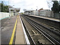
Southwick railway station, West Sussex
Opened in 1840 by the London & Brighton Railway on their line from Brighton to Shoreham-by-Sea. View east towards Fishersgate and Brighton.
Image: © Nigel Thompson
Taken: 25 Nov 2011
0.07 miles
10
Southwick Square
Viewed from The Green. Southwick's main shopping street was purpose built in 1962 as part of a major regeneration scheme replacing the old shopping area which ran along Albion Street, the A259. The consequence was to move the centre of Southwick away from the seafront where it had shifted from the mid 19th century back to the medieval centre which lay surrounding The Green, the old village common. The 'square' itself is at the eastern end before narrowing to a conventional street as it heads west.
Image: © Simon Carey
Taken: 2 Dec 2010
0.07 miles