IMAGES TAKEN NEAR TO
Croft Avenue, BRIGHTON, BN42 4AB
Introduction
This page details the photographs taken nearby to Croft Avenue, BN42 4AB by members of the Geograph project.
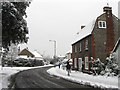
The Geograph project started in 2005 with the aim of publishing, organising and preserving representative images for every square kilometre of Great Britain, Ireland and the Isle of Man.

There are currently over 7.5m images from over14,400 individuals and you can help contribute to the project by visiting https://www.geograph.org.uk
Image Map
Images are licensed for reuse under creativecommons.org/licenses/by-sa/2.0
Notes
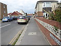
- Clicking on the map will re-center to the selected point.
- The higher the marker number, the further away the image location is from the centre of the postcode.
Image Listing (137 Images Found)
Images are licensed for reuse under creativecommons.org/licenses/by-sa/2.0
Image
Details
Distance
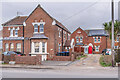
2
Adur Council Offices
Located in this old cobble fronted house on Southwick Street.
Image: © Simon Carey
Taken: 2 Dec 2010
0.09 miles
3
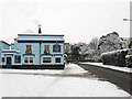
The Ship Inn
Located on the corner of Southwick Street and The Twitten and dating from the mid 19th century.
Image: © Simon Carey
Taken: 2 Dec 2010
0.10 miles
4

Railway bridge over Station Road, Southwick
Image: © John Lucas
Taken: 17 Oct 2008
0.11 miles
5
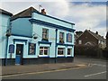
Ship Inn Southwick
near Southwick Station
Image: © Paul Gillett
Taken: 3 Apr 2010
0.11 miles
6
Electricity sub station, Whiterock Place
Image: © Alex McGregor
Taken: 11 Feb 2013
0.11 miles
8
279 & 281 and 295 & 297 Albion Street
Nos 295 & 297 are part of a row of early 20th Century former coastguard cottages, now largely hidden by 283 - 295 Albion Street (see Image). The nearer and larger nos 279 & 281 are the original Chief Officer’s house.
Image: © Ian Capper
Taken: 21 Jan 2022
0.12 miles
9
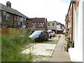
Whiterock Place
An old residential road dating from the 1850s when the area south of the railway was developed. Much of the original Victorian housing was cleared in the 1960s to make way for flats. The road itself begins at Station Road then changes its name to The Gardens at the junction with Colebrook Road and heads eastwards to join the A259 near Fishersgate.
Image: © Simon Carey
Taken: 2 Dec 2010
0.12 miles
10
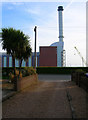
Palm Trees and Power Stations
Taken from a private drive just off Albion Street with the chimney of Shoreham Power Station looming across the horizon. The driveway leads to a row of cottages.
Image: © Simon Carey
Taken: 4 Apr 2008
0.12 miles