IMAGES TAKEN NEAR TO
Thornhill Rise, BRIGHTON, BN41 2YJ
Introduction
This page details the photographs taken nearby to Thornhill Rise, BN41 2YJ by members of the Geograph project.
The Geograph project started in 2005 with the aim of publishing, organising and preserving representative images for every square kilometre of Great Britain, Ireland and the Isle of Man.

There are currently over 7.5m images from over14,400 individuals and you can help contribute to the project by visiting https://www.geograph.org.uk
Image Map
Images are licensed for reuse under creativecommons.org/licenses/by-sa/2.0
Notes
- Clicking on the map will re-center to the selected point.
- The higher the marker number, the further away the image location is from the centre of the postcode.
Image Listing (19 Images Found)
Images are licensed for reuse under creativecommons.org/licenses/by-sa/2.0
Image
Details
Distance
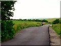
1
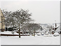
New England Rise
Heading west down the hill from Thornhill Rise where it joins Graham Crescent. The estate was developed in the 1960s to rehouse those moved from Portslade by Sea. Southwick Hill can be seen in the distance.
Image: © Simon Carey
Taken: 2 Dec 2010
0.05 miles
2
Thornhill Rise
Running along the western slope of Foredown Hill. the eastern part of Mile Oak was developed during the 1960s to place families moved from another redevelopment at Portslade by Sea.
Image: © Simon Carey
Taken: 2 Dec 2010
0.05 miles
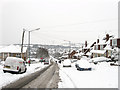
3
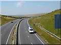
A27 Road Cutting
Road cutting through Downland just north of Southwick, dug out to accommodate the A27 that runs between Worthing and Lewes
Image: © Janine Forbes
Taken: 15 Jul 2005
0.14 miles
4
Thornhill Rise
The road turns west at the junction with Ridge Close and heads down the hill. Much of the area was developed during the 1960s.
Image: © Simon Carey
Taken: 2 Dec 2010
0.14 miles
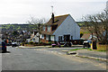
5
Chalky Road
Developed from the 1960s to rehouse those moved from Portslade by Sea, the road originally began at the junction with Thornhill Rise before heading west to Mile Oak Road, but it now continues as Fox Way eastwards to join the Hangleton Link Road. Beyond the house on the left is Portslade Community College.
Image: © Simon Carey
Taken: 2 Dec 2010
0.15 miles
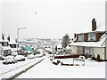
6
Thornhill Rise and Overdown Rise
Overdown Rise is at the right. Rise is appropriate for this residential area, at least in one direction. Southwick Hill is in the distance.
Image: © Robin Webster
Taken: 3 Apr 2010
0.16 miles
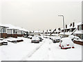
7
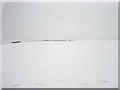
Foredown Hill
Covered in snow after 8-10 inches fell overnight. The hill is partially split but the A27.
Image: © Simon Carey
Taken: 2 Dec 2010
0.20 miles
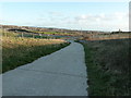
8
Start of Public Bridleway behind Ridge Close
Image: © Josie Campbell
Taken: 2 Aug 2011
0.20 miles
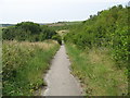
9
The Monarch's Way
Although appearing to approach Brighton and Hove the path turns acutely left.
Image: © Dave Spicer
Taken: 2 Jan 2012
0.21 miles