IMAGES TAKEN NEAR TO
Valley Road, BRIGHTON, BN41 2TP
Introduction
This page details the photographs taken nearby to Valley Road, BN41 2TP by members of the Geograph project.
The Geograph project started in 2005 with the aim of publishing, organising and preserving representative images for every square kilometre of Great Britain, Ireland and the Isle of Man.

There are currently over 7.5m images from over14,400 individuals and you can help contribute to the project by visiting https://www.geograph.org.uk
Image Map
Images are licensed for reuse under creativecommons.org/licenses/by-sa/2.0
Notes
- Clicking on the map will re-center to the selected point.
- The higher the marker number, the further away the image location is from the centre of the postcode.
Image Listing (35 Images Found)
Images are licensed for reuse under creativecommons.org/licenses/by-sa/2.0
Image
Details
Distance
1
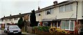
Terraced houses, North Road, Portslade
Image: © nick macneill
Taken: 17 Feb 2012
0.07 miles
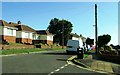
4
North Road
Terrace of houses on the edge of the centre of Portslade.
Image: © Oast House Archive
Taken: 1 Sep 2011
0.17 miles
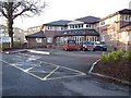
5
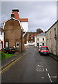
WH Catchpole Builders, Drove Road
Drove Road heads past the rear of the buildings in High Street and was most likely used as a route for moving livestock past the village towards downland pastures. The strange looking building is a builders merchants though the gantry seems to have been converted into more offices.
Image: © Simon Carey
Taken: 9 Dec 2007
0.17 miles
6
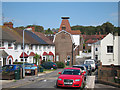
Drove Road
Looking towards former Southdowns Brewery oast house.
Image: © Oast House Archive
Taken: 1 Sep 2011
0.18 miles
7
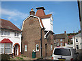
Oast House, Drove Road, Portslade
Image: © Oast House Archive
Taken: 1 Sep 2011
0.18 miles
8
Oast House, Drove Road, Portslade
Image: © Oast House Archive
Taken: 1 Sep 2011
0.18 miles
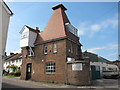
9
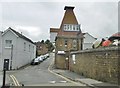
Portslade Village, malthouse
On Drove Road; former malthouse for Image The building is C19, and listed by Historic England: http://www.imagesofengland.org.uk/Details/Default.aspx?id=365518&mode=adv http://portsladehistory.blogspot.com/2014/10/portslade-brewery.html
Image: © Mike Faherty
Taken: 11 Aug 2018
0.18 miles
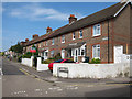
10
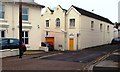
Old Brewery buildings, Drove Road and South Street, Portslade
Image: © nick macneill
Taken: 17 Feb 2012
0.19 miles