IMAGES TAKEN NEAR TO
Hillcroft, BRIGHTON, BN41 2QD
Introduction
This page details the photographs taken nearby to Hillcroft, BN41 2QD by members of the Geograph project.
The Geograph project started in 2005 with the aim of publishing, organising and preserving representative images for every square kilometre of Great Britain, Ireland and the Isle of Man.

There are currently over 7.5m images from over14,400 individuals and you can help contribute to the project by visiting https://www.geograph.org.uk
Image Map
Images are licensed for reuse under creativecommons.org/licenses/by-sa/2.0
Notes
- Clicking on the map will re-center to the selected point.
- The higher the marker number, the further away the image location is from the centre of the postcode.
Image Listing (10 Images Found)
Images are licensed for reuse under creativecommons.org/licenses/by-sa/2.0
Image
Details
Distance
1
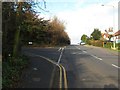
Mile Oak Road approaching Mile Oak
The turning on the left, The Rise along with Edgehill Way, was built on the site of a former LCC approved School.
Image: © Dave Spicer
Taken: 18 Dec 2012
0.02 miles
2
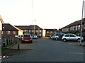
Monarchs View, Portslade
Built on the rubble of the old London County Council Reformed School.
Image: © nick macneill
Taken: 7 Dec 2012
0.06 miles
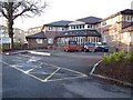
3
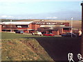
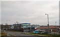
Portslade Sixth Form College
The buildings have now been replaced by houses and the sixth form college has been transferred to another site. At the time of the photo, the buildings had operated as a college for about five years, but before this they were part of the London County Council Reformed School, the main building of which was to the right of the photo.
Image: © nick macneill
Taken: Unknown
0.15 miles
4
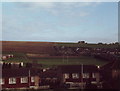
Looking towards Portslade School and Community College playing fields
Housing now covers the whole scene except for the playing fields. The water tower at the top of the hill is now a bird observatory and camera obscura.
Image: © nick macneill
Taken: 18 Nov 1983
0.15 miles
5
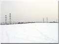
Pylons, Southwick Hill
Breaking the monotony of the white after 8-10 inches of snow fell overnight.
Image: © Simon Carey
Taken: 2 Dec 2010
0.17 miles
7
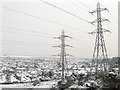
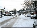
Mile Oak in the Snow
A suburb of Portslade that was gradually built up during the 20th century initially as a private development but from the 1960s as a large council enterprise to rehouse the waterside community at Portslade by Sea when that area was redeveloped. Viewed from Southwick Hill.
Image: © Simon Carey
Taken: 2 Dec 2010
0.21 miles
9
Portslade Aldridge Community College
Secondary school and sixth form with academy status located in Portslade, The school has around 900 pupils, including around 100 in the sixth form. http://en.wikipedia.org/wiki/Portslade_Aldridge_Community_Academy
College Website: http://www.paca.uk.com/
Image: © Paul Gillett
Taken: 21 Mar 2015
0.22 miles
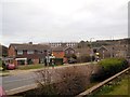
10
South along Mile Oak Road, Mile oak
The Mile Oak pub is on the right.
Image: © Dave Spicer
Taken: 2 Dec 2010
0.24 miles