IMAGES TAKEN NEAR TO
High Close, BRIGHTON, BN41 2PD
Introduction
This page details the photographs taken nearby to High Close, BN41 2PD by members of the Geograph project.
The Geograph project started in 2005 with the aim of publishing, organising and preserving representative images for every square kilometre of Great Britain, Ireland and the Isle of Man.

There are currently over 7.5m images from over14,400 individuals and you can help contribute to the project by visiting https://www.geograph.org.uk
Image Map
Images are licensed for reuse under creativecommons.org/licenses/by-sa/2.0
Notes
- Clicking on the map will re-center to the selected point.
- The higher the marker number, the further away the image location is from the centre of the postcode.
Image Listing (55 Images Found)
Images are licensed for reuse under creativecommons.org/licenses/by-sa/2.0
Image
Details
Distance
1
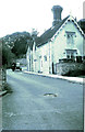
1960's photo of the High Street
The cottages were demolished sometime in the late sixties most probably due to safety reasons as double decker buses used the road. Several times the over hanging tiles were removed by the buses on their descent. Photo Image shows the road in 2013 after other road improvements.
Image: © Dave Spicer
Taken: Unknown
0.02 miles
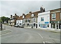
2
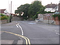
High Street Portslade Village 2013
This photo is linked to Image regarding missing cottages.
Image: © Dave Spicer
Taken: 18 Jul 2013
0.03 miles
3
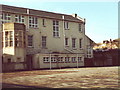
Portslade Sixth Form College
The school was a boys Secondary Modern until the early seventies when it was merged with the local girls school, forming the lower school. This changed in the nineties when it became Portslade Sixth Form College when the site at Mile Oak Road was sold for housing.
Image: © nick macneill
Taken: 9 Nov 1983
0.07 miles
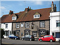
4
High Street, Upper Portslade, East Sussex
The scene is little changed in 27 years. Amazingly the two pubs, the George and the Stag are still next door to each other. The building at the top middle was a priory then, but has now been transformed into an 'Emmaus community', a place where those in need of recuperation can work. There is also a cafe and large charity shop.
Image: © nick macneill
Taken: 25 Oct 1983
0.07 miles
5
Stags Head, Portslade
A former Phoenix Inns pub on High Street.
Grade II listed http://list.english-heritage.org.uk/resultsingle.aspx?uid=118755 building facing with pebbles and black painted brick quoins.
Image: © Oast House Archive
Taken: 1 Sep 2011
0.07 miles
6
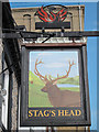
Stags Head sign
Sign for Image, a former Phoenix Inns pub on High Street.
Image: © Oast House Archive
Taken: 1 Sep 2011
0.07 miles
7
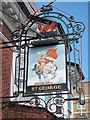
St George sign
Sign for St George pub, a former Phoenix Inns pub on High Street.
Image: © Oast House Archive
Taken: 1 Sep 2011
0.07 miles
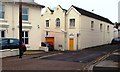
8
Portslade Village, Stag's Head
Good Beer Guide-listed public house on High Street. Historic exterior dating from C17; interior has central counter, with drinking and eating areas left and right. Legend has it that there was once a tunnel connecting the pub with Image for beer delivery. Cask ales on offer at my visit: Harvey's Best, Long Man APA, Wychwood Hobgoblin. The building is Grade II listed by Historic England: http://www.imagesofengland.org.uk/Details/Default.aspx?id=365542&mode=adv http://portsladehistory.blogspot.com/search?q=stag%27s+head
Image: © Mike Faherty
Taken: 11 Aug 2018
0.07 miles
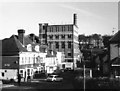
9
Old Brewery buildings, Drove Road and South Street, Portslade
Image: © nick macneill
Taken: 17 Feb 2012
0.08 miles
10
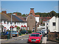
Drove Road
Looking towards former Southdowns Brewery oast house.
Image: © Oast House Archive
Taken: 1 Sep 2011
0.08 miles