IMAGES TAKEN NEAR TO
Flint Close, BRIGHTON, BN41 2GH
Introduction
This page details the photographs taken nearby to Flint Close, BN41 2GH by members of the Geograph project.
The Geograph project started in 2005 with the aim of publishing, organising and preserving representative images for every square kilometre of Great Britain, Ireland and the Isle of Man.

There are currently over 7.5m images from over14,400 individuals and you can help contribute to the project by visiting https://www.geograph.org.uk
Image Map
Images are licensed for reuse under creativecommons.org/licenses/by-sa/2.0
Notes
- Clicking on the map will re-center to the selected point.
- The higher the marker number, the further away the image location is from the centre of the postcode.
Image Listing (15 Images Found)
Images are licensed for reuse under creativecommons.org/licenses/by-sa/2.0
Image
Details
Distance
1
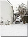
Foredown Road
Foredown Road joins Mill Lane just beyond the parked cars on the left.
Image: © Robin Webster
Taken: 3 Apr 2010
0.05 miles
2
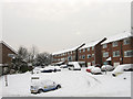
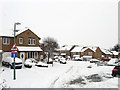
New Barn Close
A cul-de-sac off Fox Way developed along with that road in the 1990s.
Image: © Simon Carey
Taken: 2 Dec 2010
0.06 miles
3
Fox Way
A road built in the 1990s to link the new Hangleton Link Road, the A293, to the suburb of Mile Oak. Not the best road to go down after 8-10 inches of snow fell overnight though it didn't stop one idiot BMW driver bombing up it at 40 miles an hour whilst talking on his phone.
Image: © Simon Carey
Taken: 2 Dec 2010
0.08 miles
4
Hangleton Lane
Once a narrow farm track that linked Hangleton Farm to Portslade village that has been swallowed up by development in the 20th century. Viewed from the junction with Dean Gardens.
Image: © Simon Carey
Taken: 2 Dec 2010
0.12 miles
5
Vallensdean Cottages
Small terrace of cottages lying at right angles to Hangleton Lane that state on the plaque to the left that they were built in 1825 though they don't appear on the 1879 OS map. For a many decades these were the only buildings on Hangleton Lane until eventually swallowed up by suburbia.
Image: © Simon Carey
Taken: 2 Dec 2010
0.14 miles
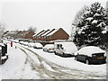
6
Crest Way
Built in the 1990s on the site of the former Foredown Hospital which had been opened in 1883 to treat infectious diseases. The hospital continued in use until the 1980s and was demolished in 1989 leaving only the former water tower, added in 1909, as a reminder.
Image: © Simon Carey
Taken: 2 Dec 2010
0.17 miles
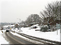
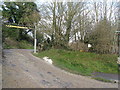
7

Foredown Road
Little more than a byway here, the road has its origins as an access route to the Downs from old village at Portslade. Today it continues beyond the A27 as a bridleway that heads north to Fulking Hill.
Image: © Simon Carey
Taken: 2 Dec 2010
0.17 miles
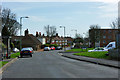
8
Roundabout, Hangleton Link Road
Other than the entrance to Sainsbury's further south the only access points to the A293, from the west is Fox Way that links the suburb of Mile Oak and to the east Hangleton Lane which leads to the suburb of Hangleton. Not surprisingly after 8-10 inches of snow fell overnight there is very little traffic on this normally busy route.
Image: © Simon Carey
Taken: 2 Dec 2010
0.20 miles
9
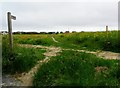
Public footpath, North Portslade
This footpath is relatively new and seems to have been part of the housing development of the nineteen eighties. It certainly did not exist in the seventies when the contributor was told to walk back the way he came by an irate farmer when crossing a ploughed field in the same position as the footpath. It would have saved me a hundred metres.
Image: © nick macneill
Taken: 21 Jun 2013
0.22 miles
10
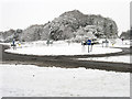
Entrance to the Benfield Valley Golf Course
This 9 hole course uses some of the old West Hove Golf Course holes.
With the building of the Brighton Bypass and the subsequent link road, the West Hove Golf Club were relocated to north of the bypass. The former clubhouse was south of the present Sainsbury's car park.
Image: © Dave Spicer
Taken: 18 Dec 2012
0.22 miles