IMAGES TAKEN NEAR TO
Hurst Crescent, BRIGHTON, BN41 1SG
Introduction
This page details the photographs taken nearby to Hurst Crescent, BN41 1SG by members of the Geograph project.
The Geograph project started in 2005 with the aim of publishing, organising and preserving representative images for every square kilometre of Great Britain, Ireland and the Isle of Man.

There are currently over 7.5m images from over14,400 individuals and you can help contribute to the project by visiting https://www.geograph.org.uk
Image Map
Images are licensed for reuse under creativecommons.org/licenses/by-sa/2.0
Notes
- Clicking on the map will re-center to the selected point.
- The higher the marker number, the further away the image location is from the centre of the postcode.
Image Listing (20 Images Found)
Images are licensed for reuse under creativecommons.org/licenses/by-sa/2.0
Image
Details
Distance
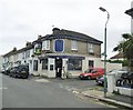
1
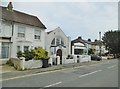
Portslade, Evangelical church
Southern Cross Evangelical Church, with nursery, on Trafalgar Road. http://www.southerncross.org.uk/
Image: © Mike Faherty
Taken: 11 Aug 2018
0.04 miles
2
Portslade, temple
Shree Swaminarayan Temple on Victoria Road: https://swaminarayan.info/temples/europe/81-shree-swaminarayan-temple-brighton-isso
Image: © Mike Faherty
Taken: 11 Aug 2018
0.06 miles
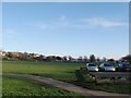
3
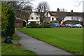
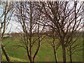
Edge of recreation ground beside Victoria Road
Image: © David Martin
Taken: 6 Jan 2018
0.09 miles
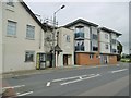
5
Portslade, Stanley Arms
Good Beer Guide-listed public house on Wolseley Road. Traditional corner house layout, with central counter and drinking areas left and right; TV, patio, games machine, open fire. Six cask ales were on offer.
Image: © Mike Faherty
Taken: 11 Aug 2018
0.12 miles
6
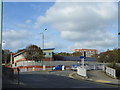
View east across the Victoria Recreation Ground
Situated between Victoria Road to the right and the A270 above the bank on the left, which was the A27 before the bypass was built.
Image: © Dave Spicer
Taken: 29 Nov 2012
0.13 miles
7
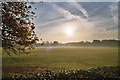
Sunrise over Victoria park
Taken from northwest corner of park which used to be a brickfield
Image: © Jean
Taken: 11 Nov 2006
0.14 miles
8
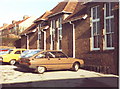
Portslade Infants School, Locks Crescent
The building was a teacher training unit at the time of the photo, but was an infants school before that and the cars are parked in the playground where I once played 'Cowboys and Indians' and had my first kiss!
Image: © nick macneill
Taken: Unknown
0.15 miles
9
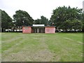
Portslade, pavilion
In Victoria Park. A notice states that the friends of the park hope to renovate it.
Image: © Mike Faherty
Taken: 11 Aug 2018
0.18 miles
10
Victoria Recreation Ground
Viewed from the Old Shoreham Road south of Portslade
Image: © Paul Gillett
Taken: 6 Dec 2009
0.18 miles