IMAGES TAKEN NEAR TO
Albion Street, BRIGHTON, BN41 1DQ
Introduction
This page details the photographs taken nearby to Albion Street, BN41 1DQ by members of the Geograph project.
The Geograph project started in 2005 with the aim of publishing, organising and preserving representative images for every square kilometre of Great Britain, Ireland and the Isle of Man.

There are currently over 7.5m images from over14,400 individuals and you can help contribute to the project by visiting https://www.geograph.org.uk
Image Map
Images are licensed for reuse under creativecommons.org/licenses/by-sa/2.0
Notes
- Clicking on the map will re-center to the selected point.
- The higher the marker number, the further away the image location is from the centre of the postcode.
Image Listing (122 Images Found)
Images are licensed for reuse under creativecommons.org/licenses/by-sa/2.0
Image
Details
Distance
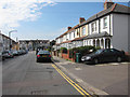
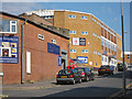
1
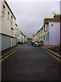
Albion Street
From the junction with North Street. Unlike other streets, except for the two warehouses at the junction with North Street the rest has retained its residential status.
Image: © Simon Carey
Taken: 9 Dec 2007
0.01 miles
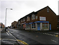
2
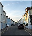
Albion Street, Portslade-By-Sea
A residential street linking North Street to St Andrew's Road. The only street that has survived from an era when all of the area between Station Road in the east, Church Road in the west and St Andrew's Road to north was a community of tight knit terraced housing that made up the settlement of Portslade-By-Sea. The vast majority was demolished in the 1950s as slum housing and the area given over to business units and small factories.
Image: © Simon Carey
Taken: 17 May 2020
0.01 miles
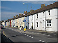
3
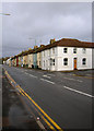
Church Road
The B2139 linking Wellington Road (A259) with Old Shoreham Road (A270), The row of terraced houses are a reminder of the residential district that once existed here before the removal of most of the houses for slum clearances in the 1950s and replaced with warehouses and factories.
Image: © Simon Carey
Taken: 9 Dec 2007
0.04 miles
6
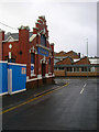
Grate Fireplaces, 79 North Street
On the junction with Church Road. This is their old showroom having recently decamped further up the road to 92-98 North Street.
Image: © Simon Carey
Taken: 9 Dec 2007
0.05 miles
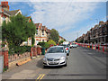
7
Church Road
Terraced residential section of the road.
Image: © Oast House Archive
Taken: 1 Sep 2011
0.05 miles
8
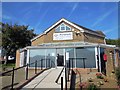
Portslade Dental Centre
Website: http://www.portsladedentalcentre.co.uk/
Image: © Paul Gillett
Taken: 24 Sep 2013
0.06 miles
10
Majestic Bathrooms, North Street
On the junction with Middle Street. North Street was once a residential street that was cleared sometime in the late 1950s early 1960s and turned into warehouses and factories.
Image: © Simon Carey
Taken: 9 Dec 2007
0.06 miles