IMAGES TAKEN NEAR TO
Greenleas, HOVE, BN3 8AD
Introduction
This page details the photographs taken nearby to Greenleas, BN3 8AD by members of the Geograph project.
The Geograph project started in 2005 with the aim of publishing, organising and preserving representative images for every square kilometre of Great Britain, Ireland and the Isle of Man.

There are currently over 7.5m images from over14,400 individuals and you can help contribute to the project by visiting https://www.geograph.org.uk
Image Map
Images are licensed for reuse under creativecommons.org/licenses/by-sa/2.0
Notes
- Clicking on the map will re-center to the selected point.
- The higher the marker number, the further away the image location is from the centre of the postcode.
Image Listing (27 Images Found)
Images are licensed for reuse under creativecommons.org/licenses/by-sa/2.0
Image
Details
Distance
1
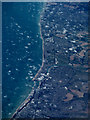
Shoreham-by-sea and the south coast from the air
Viewed from a Paris bound flight from Glasgow.
Image: © Thomas Nugent
Taken: 30 Aug 2016
0.09 miles
2
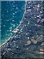
Shoreham-by-sea and the south coast from the air
Portslade Village, Shoreham Beach and the River Adur can be seen in this photo which was taken from a Paris bound flight from Glasgow. Brighton City Airport and Worthing can also be seen.
Image: © Thomas Nugent
Taken: 30 Aug 2016
0.09 miles
3
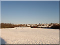
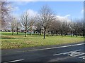
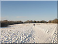
Greenleas Recreation Ground
Large public park on the western side of Hangleton next to the Benfield Valley Nature Reserve.
Image: © Simon Carey
Taken: 7 Jan 2010
0.09 miles
5
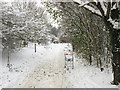
Footpath to Benfield Way
Leaving the main north-south route through Benfield Valley before heading under the A293 then towards Benfield Way. A couple of discarded trolleys line the route.
Image: © Simon Carey
Taken: 2 Dec 2010
0.16 miles
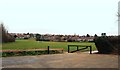
6
St Helens Park, Hangleton
Park south of St Helens Church
Image: © Paul Gillett
Taken: 7 Dec 2012
0.17 miles
7
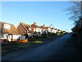
Hangleton Gardens, Hangleton, Hove
A residential road that links Hangleton Way to Hangleton Road, the A2038. Originally the road was a country lane heading east to West Blatchington from the old lane to Hangleton that formed the northern border of the parish of Aldrington. As the area was developed in the mid to late 1930s, Hangleton Road was widened and given a curve a little to the south reducing this former part as a quiet residential backwater. The houses on the left were built in the late 1930s.
Image: © Simon Carey
Taken: 22 Dec 2016
0.17 miles
9
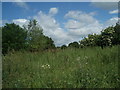
Benfield Valley Local Nature Reserve
A narrow strip of land separating Portslade from the suburb of Hangleton. Formerly part of West Hove Golf Club which operated here from 1910 to 1991 before the by-pass split their course in two and took away some land to build the Hangleton Link Road caused them to relocate north of the A27. This section between Sainsbury's and Hangleton Lane is now an open public space with footpaths linking the nature reserve with the two suburbs mentioned above.
Image: © Simon Carey
Taken: 7 Jan 2010
0.18 miles
10
Plant and shrubs
Photo taken behind Hove Sainsbury's
Image: © Paul Gillett
Taken: 20 Jun 2009
0.18 miles