IMAGES TAKEN NEAR TO
Nevill Place, HOVE, BN3 7QJ
Introduction
This page details the photographs taken nearby to Nevill Place, BN3 7QJ by members of the Geograph project.
The Geograph project started in 2005 with the aim of publishing, organising and preserving representative images for every square kilometre of Great Britain, Ireland and the Isle of Man.

There are currently over 7.5m images from over14,400 individuals and you can help contribute to the project by visiting https://www.geograph.org.uk
Image Map
Images are licensed for reuse under creativecommons.org/licenses/by-sa/2.0
Notes
- Clicking on the map will re-center to the selected point.
- The higher the marker number, the further away the image location is from the centre of the postcode.
Image Listing (95 Images Found)
Images are licensed for reuse under creativecommons.org/licenses/by-sa/2.0
Image
Details
Distance
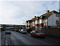
1
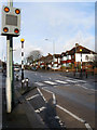
Zebra Crossing, Nevill Road
Just before the crossroads of Nevill Road with Nevill Place, to the left, and Nevill Way, to the right. This part of the road follows the course of an ancient east-west droveway which passed through the then small villages of Preston and West Blatchington. It was given the name in 1928 and the area built up from the late 1930s.
Image: © Simon Carey
Taken: 18 Jan 2009
0.04 miles
2
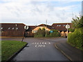
Nevill Gardens
Small cul-de-sac running south from Nevill Road and built in the late 1930s.
Image: © Simon Carey
Taken: 18 Jan 2009
0.05 miles
3
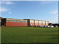
Sports Hall, Blatchington Mill School
Viewed from Nevill Playing Field it is the eastern most structure of the school that was formed in 1979 on the amalgamation of Hove School for Boys and Nevill Secondary School.
Image: © Simon Carey
Taken: 18 Jan 2009
0.05 miles
4
Aldrington Primary School
The buildings are new but the school is quite old, having opened in 1888 on Portland Road. However, the school became cramped and unable to expand so moved to this site in 1990 its old main building becoming a nursery. Viewed from the one way access road that takes you in via Eridge Road and out onto Nevill Avenue to the south.
Image: © Simon Carey
Taken: 18 Jan 2009
0.06 miles
5
Frant Road
Small cul-de-sac that leads south of Nevill Road which was built in the 1930s. Blatchington Mill School is beyond.
Image: © Simon Carey
Taken: 18 Jan 2009
0.07 miles
6
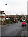
Nevill Way
Linking Nevill Road with Goldstone Crescent and showing the drop the land makes as it descends into what once was Goldstone Bottom.
Image: © Simon Carey
Taken: 18 Jan 2009
0.09 miles
7
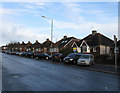
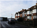
Nevill Road
I wonder if the estate agent selling one of the houses opposite will promote the off road parking facility. This part of Nevill Road was originally an ancient east-west droveway that followed the Downs through the then small villages of Preston and West Blatchington. Nevill Road was named in 1928 and built up when Hove corporation took over the running of the former parish of West Blatchington, with many of the houses built in the late 1930s. Taken from the corner of Eridge Road the land drops into what was once Goldstone Bottom behind the houses.
Image: © Simon Carey
Taken: 18 Jan 2009
0.09 miles
8
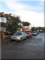
Eridge Road
The first of 5 small cul-de-sacs that leave the southern side of Nevill Road and Court Farm Road though it is also the access road for Aldrington Primary School, North Nevill allotments and Nevill Playing Field. All were constructed in the late 1930s.
Image: © Simon Carey
Taken: 18 Jan 2009
0.09 miles
9
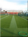
Cricket Nets, Nevill Playing Fields
The picture is straight it's just the metal poles that hold the nets are actually at an angle. The nets are at the northern end of the playing field with the gym from Blatchington Mill School visible in the background.
Image: © Simon Carey
Taken: 18 Jan 2009
0.10 miles
10
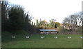
Covered Reservoir
Built in 1884 along with the nearby waterworks that is now the British Engineerium museum. Viewed over a wall from Woodlands Drive they have been talks of developing the piece of land in the foreground but have been held up by protests.
Image: © Simon Carey
Taken: 18 Jan 2009
0.10 miles