IMAGES TAKEN NEAR TO
Acacia Avenue, HOVE, BN3 7JT
Introduction
This page details the photographs taken nearby to Acacia Avenue, BN3 7JT by members of the Geograph project.
The Geograph project started in 2005 with the aim of publishing, organising and preserving representative images for every square kilometre of Great Britain, Ireland and the Isle of Man.

There are currently over 7.5m images from over14,400 individuals and you can help contribute to the project by visiting https://www.geograph.org.uk
Image Map
Images are licensed for reuse under creativecommons.org/licenses/by-sa/2.0
Notes
- Clicking on the map will re-center to the selected point.
- The higher the marker number, the further away the image location is from the centre of the postcode.
Image Listing (94 Images Found)
Images are licensed for reuse under creativecommons.org/licenses/by-sa/2.0
Image
Details
Distance
1
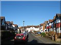
Acacia Avenue, Hove
A short residential road that links maple Gardens to Elm Drive that was developed in the 1930s in the northern end of the former parish of Aldrington.
Image: © Simon Carey
Taken: 5 Jan 2017
0.02 miles
2
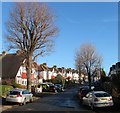
Maple Gardens, Hove
A residential road that links Elm Drive to Acacia Avenue that was developed in the 1930s.
Image: © Simon Carey
Taken: 5 Jan 2017
0.03 miles
3
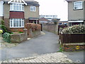
Public footpath to Old Shoreham Road
From Maple Gardens.
Image: © Peter Holmes
Taken: 17 Mar 2012
0.03 miles
4
Elm Drive, Hove
A residential road that links Holmes Avenue to Hangleton Road that was developed in the 1930s in the northern part of the former parish of Aldrington.
Image: © Simon Carey
Taken: 5 Jan 2017
0.04 miles
5
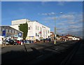
Solutions Inc, Old Shoreham Road
Directly opposite, Image is the local suppliers for Apple products who also have a small store in the centre of town. Both the store and small unit on the far side lie above what was once the Dyke railway that operated between 1887-1939 which went under the road at this point. It has long been filled in and much of the course is now built over. Old Shoreham Road is the A270.
Image: © Simon Carey
Taken: 14 Jan 2009
0.04 miles
6
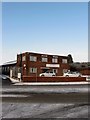
Maple Works, Old Shoreham Road
Former small factory that appears to have been subdivided into a number of smaller business units. The factory was built in the post war era on the site of a filled in cutting that carried the former Dyke Railway that operated from 1887 to 1938.
Image: © Simon Carey
Taken: 7 Jan 2010
0.04 miles
7
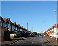
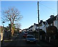
Holmes Avenue, Hove
A residential road that connects Old Shoreham Road to Hangleton Road that was built in stages during the 1930s. This section as far as the old parish boundary between Aldrington and West Blatchington had been completed by the early 1930s.
Image: © Simon Carey
Taken: 5 Jan 2017
0.05 miles
8

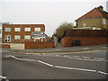
Maple Works, Old Shoreham Road, Hove
Former engineering works that was built in the 1950s on the old trackbed of the Dyke Railway which passed under the Old Shoreham Road at this point between 1887-1938. The works have been split into smaller units with this one occupied by Ticket Media. The frontage was rebuilt around 2010, see Image, due to structural defects possibly caused by its location on a filled in cutting.
Image: © Simon Carey
Taken: 5 Jan 2017
0.06 miles
9
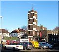
Drill Tower, Hove Fire Station, English Close, Hove
Located on the eastern side of the station whose offices are out of shot to the left. Built around 1963 it occupies the former trackbed of the Dyke Railway which operated from 1887 to 1938.
Image: © Simon Carey
Taken: 5 Jan 2017
0.07 miles
10
Public footpath to Maple Gardens
Adjacent to offices of Ticketmedia, Maple Works, Old Shoreham Road built on the old Dyke Railway route.
Image: © Peter Holmes
Taken: 17 Mar 2012
0.07 miles