IMAGES TAKEN NEAR TO
Hallyburton Road, HOVE, BN3 7GN
Introduction
This page details the photographs taken nearby to Hallyburton Road, BN3 7GN by members of the Geograph project.
The Geograph project started in 2005 with the aim of publishing, organising and preserving representative images for every square kilometre of Great Britain, Ireland and the Isle of Man.

There are currently over 7.5m images from over14,400 individuals and you can help contribute to the project by visiting https://www.geograph.org.uk
Image Map
Images are licensed for reuse under creativecommons.org/licenses/by-sa/2.0
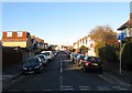
Notes
- Clicking on the map will re-center to the selected point.
- The higher the marker number, the further away the image location is from the centre of the postcode.
Image Listing (77 Images Found)
Images are licensed for reuse under creativecommons.org/licenses/by-sa/2.0
Image
Details
Distance
1
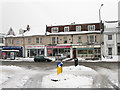
A Nation of Shopkeepers !
Shops at the top end of Boundary Road
Image: © Bob Parkes
Taken: 9 Nov 2007
0.04 miles
2
Shops, Boundary Road
Small parade of shops north of the junction with Hallyburton Road. Boundary Road/Carlton Terrace-Station Road has been the major shopping area of Portslade since the 1930s.
Image: © Simon Carey
Taken: 2 Dec 2010
0.04 miles
3
87a, Boundary Road, Hove
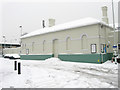
Tucked away behind the eastbound platform of Portslade station is the local job centre built in the 1960s.
Image: © Simon Carey
Taken: 22 Dec 2016
0.04 miles
4
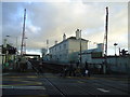
Portslade Station
The original station was opened on the western side of Station Road/Boundary Road and was moved to this position in 1881. This building on the northern side is a former booking office no longer in use.
Image: © Simon Carey
Taken: 2 Dec 2010
0.04 miles
6
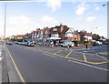
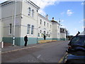
Boundary Road/Carlton Terrace
The houses on the left are on Boundary Road, those on the right are on Carlton Terrace. This is the northern end of the B2194, see Image for the southern end and an explanation about why the road has two names.
Image: © Simon Carey
Taken: 2 Dec 2010
0.05 miles
7
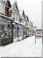
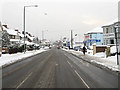
Shops, Carlton Terrace
Viewed from Hallyburton Road. The B2194 became Portslade's major shopping street from the 1930s having previously been a residential road.
Image: © Simon Carey
Taken: 2 Dec 2010
0.06 miles
8
Gladys Road, Hove
A residential road that originally ran from Hallyburton Road to Old Shoreham Road, then the A27. The northern junction with the latter was closed in the 1970s when the road was widened. Part of the Hallyburton estate which was developed in 1925 between the railway and Old Shoreham Road on a former field called Barn Field, according to Aldrington's 1841 tithe map, with the roads named after a local landowner and both his and the builder's daughters.
Image: © Simon Carey
Taken: 3 Dec 2016
0.07 miles
9
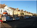
385-413, Portland Road, Hove
These terraced houses on the northern side of the road were built in the 1920s on the site of former allotment gardens.
Image: © Simon Carey
Taken: 3 Dec 2016
0.07 miles