IMAGES TAKEN NEAR TO
Hangleton Road, HOVE, BN3 7GG
Introduction
This page details the photographs taken nearby to Hangleton Road, BN3 7GG by members of the Geograph project.
The Geograph project started in 2005 with the aim of publishing, organising and preserving representative images for every square kilometre of Great Britain, Ireland and the Isle of Man.

There are currently over 7.5m images from over14,400 individuals and you can help contribute to the project by visiting https://www.geograph.org.uk
Image Map
Images are licensed for reuse under creativecommons.org/licenses/by-sa/2.0
Notes
- Clicking on the map will re-center to the selected point.
- The higher the marker number, the further away the image location is from the centre of the postcode.
Image Listing (48 Images Found)
Images are licensed for reuse under creativecommons.org/licenses/by-sa/2.0
Image
Details
Distance
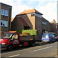
1
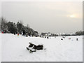
Sledging, Benfield Valley Playing Field
Making use of the 8-10 inches of snow that fell overnight. The playing field to the right was once part of West Hove Golf Course which moved when the Hangelton Link Road was built in the 1990s transferring their course to a new one north of the A27.
Image: © Simon Carey
Taken: 2 Dec 2010
0.07 miles
2
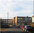
St Richard's Court, Bellingham Crescent, Knoll Estate, Hove
A block of flats built in the 1960s at the junction with Egmont Road and located to the immediate south of Image
The Knoll Estate is located in the former northern portion of the parish of Aldrington which was once three open fields called The Knowle East, The Knowle West and The Knowle North according to its 1840 tithe map. The area was developed by Hove council from 1926 and mostly completed by 1939, the remaining undeveloped part at the northern end of Stapley Road was finished in the late 1940s.
Image: © Simon Carey
Taken: 22 Dec 2016
0.08 miles
3
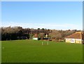
Benfield Valley Pavilion, Hove
The sports pavilion for the football and cricket pitches. Located to north of Old Shoreham Road, the A270 it was originally the southern most field in the parish of Hangleton called Upper and Lower Dean according to its 1841 tithe map. In 1910 Benfield valley was converted into the West Hove Golf Course who remained until 1991 when construction of the Brighton By-Pass including the Hangleton Link Road caused it to relocate north of the A27. The area south of Hangleton Lane was split between a Sainsbury's superstore and a new park.
Image: © Simon Carey
Taken: 22 Dec 2016
0.09 miles
4
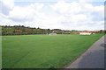
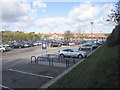
Playing Fields - Hangleton
The Playing Fields at Hangleton with Sainsbury's beyond
Image: © Bob Parkes
Taken: 9 Nov 2007
0.09 miles
5
St Richard's Church, Egmont Road, Knoll Estate, Hove
Church and community centre built in the 1930s near the junction with Bellingham Crescent.
The Knoll Estate is located in the former northern portion of the parish of Aldrington which was once three open fields called The Knowle East, The Knowle West and The Knowle North according to its 1840 tithe map. The area was developed by Hove council from 1926 and mostly completed by 1939, the remaining undeveloped part at the northern end of Stapley Road was finished in the late 1940s.
Image: © Simon Carey
Taken: 22 Dec 2016
0.10 miles
6
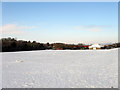
Playing Field, Benfield Valley
The valley is the name given to a strip of green that runs from the A270 northwards separating the suburbs of Portslade and Hangleton. It continues north of the by-pass until it rises near Dyke Farm. Prior to 1991 this was West Hove Golf Course which had been established in 1910 but had to relocate when the new by-pass split the old course in two. The southern end of the course which also contained the old clubhouse is now a playing field.
Image: © Simon Carey
Taken: 7 Jan 2010
0.11 miles
7
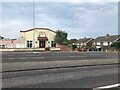
Christian Arabic Evangelical Church
Not a denomination I've come across before.
Image: © David Lally
Taken: 11 Jun 2023
0.11 miles
8
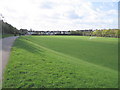
Playing Fields - Hangleton
The Playing Fields at Hangleton with the A270 in the distance.
Image: © Bob Parkes
Taken: 9 Nov 2007
0.11 miles
10
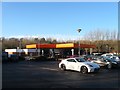
Sainsbury's Petrol Station, Hove
Located off the Hangleton Link Road, the A293, and opened in the early 1990s.
Image: © Simon Carey
Taken: 22 Dec 2016
0.12 miles