IMAGES TAKEN NEAR TO
Sackville Road, HOVE, BN3 7AA
Introduction
This page details the photographs taken nearby to Sackville Road, BN3 7AA by members of the Geograph project.
The Geograph project started in 2005 with the aim of publishing, organising and preserving representative images for every square kilometre of Great Britain, Ireland and the Isle of Man.

There are currently over 7.5m images from over14,400 individuals and you can help contribute to the project by visiting https://www.geograph.org.uk
Image Map (Loading...)


Getting Data...Please wait
Leaflet Map data © OpenStreetMap
Images are licensed for reuse under creativecommons.org/licenses/by-sa/2.0
Notes
- Clicking on the map will re-center to the selected point.
- The higher the marker number, the further away the image location is from the centre of the postcode.
Image Listing (120 Images Found)
Images are licensed for reuse under creativecommons.org/licenses/by-sa/2.0
Image
Details
Distance
1
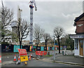
Development, Sackville Road, Hove
A trading estate (Image]) has largely been cleared for a new housing development, which will also include offices and public gardens. Housing will include more than 500 build to rent homes and 260 care community homes (whatever they are). Developers Moda Living.
Image: © Stephen Richards
Taken: 26 Dec 2021
0.03 miles
4
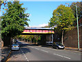
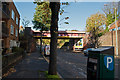
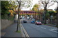
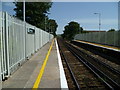
Sackville Road Bridge
Carrying the West Coastway line over the A2023. Originally an arch bridge it was replaced when the road was widened.
Image: © Simon Carey
Taken: 14 Oct 2007
0.06 miles
5
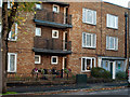
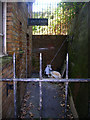
Public toilets occupy the corner of this block of flats
Sackville Road, Hove. Just below the railway bridge.
Image: © Roger A Smith
Taken: 4 Nov 2012
0.06 miles
7
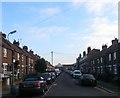
Sheridan Terrace, Hove
The current road runs in a loop off Coleridge Street with this section the northern segment. Named after Richard Brinsely Sheridan and part of the district known locally as Poets Corner due to the street names rather than any bohemian tendencies. Originally the eastern and western parts were constructed and known as Sheridan Place and Sheridan Street respectively with this section occupied by Salvation Army barracks until their demolition in the mid 1930s and replaced with these houses and flats before World War Two renaming the street in the process.
Image: © Simon Carey
Taken: 17 Dec 2016
0.07 miles
8
Sheridan Terrace
In the area known as Poet's Corner due to the street names all being named after poets rather than anything resembling a Bohemian lifestyle. Much of the housing is terraced built for the tradesman who serviced the great and good in the villas between Portland Road and the sea. The street runs in a crescent and starts and finishes on Coleridge Street.
Image: © Simon Carey
Taken: 14 Jan 2009
0.07 miles
9
Former Public Lavatory, Sackville Road
Built into the ground floor of a block of flats erected during the 1960s on the western side of Sackville Road leading up to the railway bridge. The ladies front out onto the road whilst the gents was round the corner down an alley. Neither are in use anymore.
Image: © Simon Carey
Taken: 14 Oct 2007
0.07 miles
10
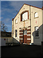
Salvation Army Citadel, Sackville Road
Sackville Road is down the stairs to the left. The citadel opened in 1880 and is still used today.
Image: © Simon Carey
Taken: 14 Jan 2009
0.09 miles