IMAGES TAKEN NEAR TO
Windsor Close, HOVE, BN3 6WS
Introduction
This page details the photographs taken nearby to Windsor Close, BN3 6WS by members of the Geograph project.
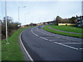
The Geograph project started in 2005 with the aim of publishing, organising and preserving representative images for every square kilometre of Great Britain, Ireland and the Isle of Man.

There are currently over 7.5m images from over14,400 individuals and you can help contribute to the project by visiting https://www.geograph.org.uk
Image Map
Images are licensed for reuse under creativecommons.org/licenses/by-sa/2.0
Notes
- Clicking on the map will re-center to the selected point.
- The higher the marker number, the further away the image location is from the centre of the postcode.
Image Listing (13 Images Found)
Images are licensed for reuse under creativecommons.org/licenses/by-sa/2.0
Image
Details
Distance
1
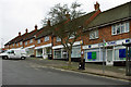
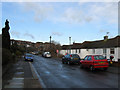
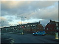
Parade of shops, Queen Victoria Avenue
One or two are hardly shops, e.g. "Gym & Tonic".
Image: © Robin Webster
Taken: 7 Apr 2010
0.17 miles
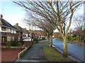
2
Poynings Drive, Hangleton, Hove
Residential road built in the 1940s heading north from Downlands Drive.
Image: © Simon Carey
Taken: 15 Apr 2020
0.17 miles
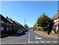
3
Nevill Road
The A2023 leaves the square and is about to meet the junction with the A2038. The South Downs can be seen in the distance to the left. This part of the road was built up from the 1930s and originally Nevill Road remained the name up to the junction with Dyke Road, however, that part was renamed King George VI Avenue in 1936. The block of flats to the right are Balmoral Court.
Image: © Simon Carey
Taken: 18 Jan 2009
0.18 miles
4
King George VI Avenue, Hove (A2038)
The outskirts of Hove looking towards junction with A27(T).
Image: © Peter Holmes
Taken: 26 Jan 2008
0.19 miles
5
Goldstone Way
Small road linking Nevill Way with Goldstone Crescent that follows the western slope of the former Goldstone Bottom. Most of the housing was built in the 1950s.
Image: © Simon Carey
Taken: 18 Jan 2009
0.21 miles
6
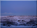
Toads Hole Valley at Dusk
Taken from Downland Drive. The area is owned privately and may well end up becoming a small estate of industrial units some time in the near future. It is bounded by the A27 Brighton by-pass on the left whose junction with Dyke Road can be made out by the street lights and King George VI Avenue, the A2038, to the right. Both converge at Red Hill in the centre.
Image: © Simon Carey
Taken: 7 Jan 2010
0.21 miles
7
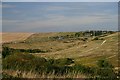
South Downs from the northern edge of Hove
The A27 cuts across the Downs to the north of Hove. In the middle ground are tracks made by motorcycle scramblers.
Image: © Bob Jones
Taken: 9 Aug 2005
0.22 miles
8
Hangleton Road, junction with Court Farm Road
Image: © Stacey Harris
Taken: 17 Dec 2011
0.23 miles
9
Goldstone Crescent
Long road connecting Old Shoreham Road, the A270, with King George VI Avenue, the A2038, and consequently has been known to have been a bit of a rat run though this has lessened since the building of the bypass. As part of the deal in buying the land for Hove Park, the Nevill family had an option to develop what was soon known as Goldstone Crescent being marked as such on 1911 map. However, development was taken up until the 1920s and most of the length of road had been built upon by the end of the 1930s.
Image: © Simon Carey
Taken: 18 Jan 2009
0.23 miles