IMAGES TAKEN NEAR TO
West View, The Drive, HOVE, BN3 6JB
Introduction
This page details the photographs taken nearby to West View, The Drive, BN3 6JB by members of the Geograph project.
The Geograph project started in 2005 with the aim of publishing, organising and preserving representative images for every square kilometre of Great Britain, Ireland and the Isle of Man.

There are currently over 7.5m images from over14,400 individuals and you can help contribute to the project by visiting https://www.geograph.org.uk
Image Map
Images are licensed for reuse under creativecommons.org/licenses/by-sa/2.0
Notes
- Clicking on the map will re-center to the selected point.
- The higher the marker number, the further away the image location is from the centre of the postcode.
Image Listing (182 Images Found)
Images are licensed for reuse under creativecommons.org/licenses/by-sa/2.0
Image
Details
Distance
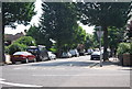
3
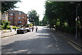
Wilbury Avenue
Looking towards the junction with the B2186 The Drive. The road continues beyond to Hove Park Villas. Devonshire Court is to the left and White Lodge to the right. The road was laid out in 1891.
Image: © Simon Carey
Taken: 28 May 2006
0.03 miles
5
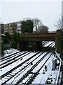
Wilbury Villas Railway Bridge
The track on the right hand side heads to Brighton that on the left towards the Cliftonville Spur and eventually London. Janeston Court is to the left.
Image: © Simon Carey
Taken: 6 Apr 2008
0.03 miles
7
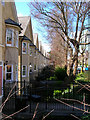
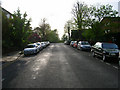
Champions Row, Wilbury Avenue
Built in 1999 on the site of the Palmeira Tennis Club. The story is that the Tennis Club put up the land for sale thinking that the council would not give planning consent. However, they did, the club moved to courts in The Droveway and made a handsome profit from it. The original banking means all the houses have lower ground floors and walkways connecting them to their front door.
Image: © Simon Carey
Taken: 8 Apr 2006
0.05 miles
8
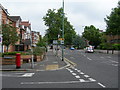
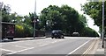
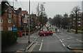
The Drive at the junction of Wilbury Avenue, Hove
The direction sign refers to a junction just ahead, with traffic lights.
Image: © Danny P Robinson
Taken: 31 May 2007
0.05 miles
9
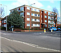
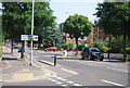
Lincoln Court
Located at the junction of The Drive (B2185) and The Upper Drive. Both roads were laid out when land was developed from the Stanford Estate. These roads linked Hove with Preston where the Stanford family were lords of the manor. Lincoln Court was built on empty land in the early 1960s. This view looks east north east.
Image: © Simon Carey
Taken: 25 Feb 2006
0.05 miles