IMAGES TAKEN NEAR TO
The Drive, HOVE, BN3 6FU
Introduction
This page details the photographs taken nearby to The Drive, BN3 6FU by members of the Geograph project.
The Geograph project started in 2005 with the aim of publishing, organising and preserving representative images for every square kilometre of Great Britain, Ireland and the Isle of Man.

There are currently over 7.5m images from over14,400 individuals and you can help contribute to the project by visiting https://www.geograph.org.uk
Image Map
Images are licensed for reuse under creativecommons.org/licenses/by-sa/2.0
Notes
- Clicking on the map will re-center to the selected point.
- The higher the marker number, the further away the image location is from the centre of the postcode.
Image Listing (132 Images Found)
Images are licensed for reuse under creativecommons.org/licenses/by-sa/2.0
Image
Details
Distance
1
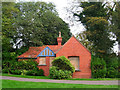
No Longer Convenient, Hove Recreation Ground
Based in the south east corner of the park near the entrance which itself is on the crossroads of Old Shoreham Road (A270), The Drive (B2186) and Shirley Drive. I believe this lodge-like structure is a former public convenience though it looks like it could have been built as a park keeper's lodge. The recreation ground itself is surrounded by a number of different species of Elm.
Image: © Simon Carey
Taken: 16 Sep 2006
0.00 miles
2
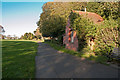
A building in Hove Recreation Ground near the Old Shoreham Road
Image: © Roger A Smith
Taken: 4 Nov 2012
0.04 miles
3
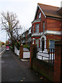
Park Nursing Home, Old Shoreham Road
Other than being subdivided into flats the big Victorian and Edwardian villas seem to also be occupied by nursing homes. This one is opposite Hove Recreation Ground hence its name.
Image: © Simon Carey
Taken: 2 Dec 2006
0.06 miles
4
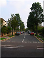
Shirley Road
Taken from the junction with Shirley Drive the area was developed between 1893-1920 on land purchased from the Stanford Estate. A good example of leafy suburban Hove.
Image: © Simon Carey
Taken: 16 Sep 2006
0.06 miles
5
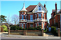
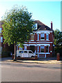
112 The Drive
First of three houses all built in a similar style with the tower and weather vane all on the corner of a junction with Old Shoreham Road and all facing West. This one is on the corner of the junction Old Shoreham Road (A270) and The Drive (B2185). This view looks east towards the house which was erected in the late 1890s and is the only one of three that retains its original design. The other two can be found at Image] and Image
Image: © Simon Carey
Taken: 19 Mar 2006
0.07 miles
6
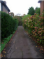
Driveway, Old Shoreham Road
Leading to a house that occupies the area between Old Shoreham Road and Shirley Road.
Image: © Simon Carey
Taken: 11 Nov 2006
0.07 miles
8
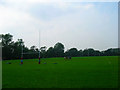
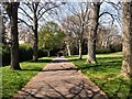
Talking Tactics, Hove Recreation Ground
Home to Hove Rugby Club the recreation ground has been a public park since 1908.
Image: © Simon Carey
Taken: 16 Sep 2006
0.08 miles
9
The Drive Prep School
Independent co-educational school based in a big Edwardian villa in The Drive near the junction with the A270 Old Shoreham Road.
Image: © Simon Carey
Taken: 19 Nov 2006
0.09 miles
10
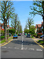
Rigden Road
Built up from 1928 onwards and named after a local farmer whom the land was purchased from. The northern limits of this grid square is just beyond the lime green car on the right. Taken from the junction with Shirley Road.
Image: © Simon Carey
Taken: 11 Jun 2006
0.09 miles