IMAGES TAKEN NEAR TO
Lyndhurst Corner, Lyndhurst Road, HOVE, BN3 6FR
Introduction
This page details the photographs taken nearby to Lyndhurst Corner, Lyndhurst Road, BN3 6FR by members of the Geograph project.
The Geograph project started in 2005 with the aim of publishing, organising and preserving representative images for every square kilometre of Great Britain, Ireland and the Isle of Man.

There are currently over 7.5m images from over14,400 individuals and you can help contribute to the project by visiting https://www.geograph.org.uk
Image Map
Images are licensed for reuse under creativecommons.org/licenses/by-sa/2.0
Notes
- Clicking on the map will re-center to the selected point.
- The higher the marker number, the further away the image location is from the centre of the postcode.
Image Listing (184 Images Found)
Images are licensed for reuse under creativecommons.org/licenses/by-sa/2.0
Image
Details
Distance
1
Holland Road Bridge
Carrying the northern part of Holland Road which extends right down to the seafront over the West Coastway Line towards the junction with Lyndhurst. The original Hove station once existed beyond the parapet to the left but when it moved to its current site the station was downgraded and renamed Holland Road Halt until it closed in 1956.
Image: © Simon Carey
Taken: 18 Dec 2009
0.01 miles
2
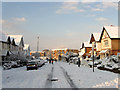
Lyndhurst Road
Looking down towards the western end of the road with Lyndhurst Court the block of flats beyond.
Image: © Simon Carey
Taken: 18 Dec 2009
0.03 miles
3
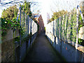
Burton Walk
A small footpath that links Wilbury Avenue with Silverdale Road, taking itself over the Cliftonville Spur railway line in the process. This view is taken from the Silverdale Road end looking north west over the footbridge. The house at the far end is the only residence in Burton Walk. The exit is around the corner just beyond.
Image: © Simon Carey
Taken: 22 Jan 2006
0.03 miles
4
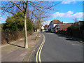
Silverdale Avenue
Starts at the point where Lyndhurst Road turns 90 degrees north takes two turns to the east before ending at Silverdale Road. This section runs parallel with the Cliftonville Spur railway line which is to the left. This view looks north easterly from the first bend in the road.
Image: © Simon Carey
Taken: 5 Mar 2006
0.03 miles
5
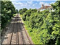
Holland Road Halt railway station (site), Sussex
Opened in 1905 by the London Brighton & South Coast Railway on the line from Brighton to Portsmouth, this station was adjacent to the site of Hove's first railway station, immediately behind the camera position. See Image In turn, this station, which had two parallel platforms built of timber, closed in 1956. Access was down steps from the Holland Road overbridge.
View west towards the current Hove station and Portsmouth. No trace apparently remains.
Image: © Nigel Thompson
Taken: 13 Jul 2021
0.03 miles
6
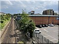
Hove 1st railway station (site), Sussex
Opened in 1840 by the London & Brighton Railway on what is today the line from Brighton to Portsmouth, this station closed in 1880.
View east towards Brighton. After closure to passengers, this site was used as a goods station until the 1970s. The original station building would have been where the small tree now is.
Image: © Nigel Thompson
Taken: 13 Jul 2021
0.03 miles
7
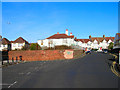
Holland Road Railway Bridge
Holland Road's southern end begins on the A259 and northern end ends just over the railway bridge with its junction with Lyndhurst Road as seen in the picture. In fact it originally ended at the brick wall to the left of the picture as the road originally served the first Hove station that was built in 1840 to the east of this picture. This closed in 1880 with the land around becoming a goods yard. However, another station, Holland Road Halt was built below the brick wall and opened in 1905 and remained in use until it was shut in 1956. The entrance was on the very left of the picture and required passengers to walk down a flight of steps to the wooden platforms. Nothing now remains of the halt.
Image: © Simon Carey
Taken: 22 Jan 2006
0.04 miles
8
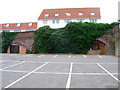
Former Railway Arches, Peacock Industrial Estate
The only reminder of a railway coal yard that once existed on this site. The railway line is out of the picture to the right, a balustrade on Holland Road bridge is just visible. The arches were originally used to stable the horses of the yard but now are boarded up. The coal yard lasted until the early 1970s and the area is now an industrial estate and home to a DIY, bathroom and carpet warehouse.
Image: © Simon Carey
Taken: 24 Dec 2006
0.04 miles
9
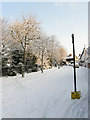
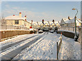
Silverdale Avenue
The road heads north before turning east towards a junction with Silverdale Road. About 10cm of snow fell overnight and by the looks of things nothing has attempted to drive down this road.
Image: © Simon Carey
Taken: 18 Dec 2009
0.04 miles
10
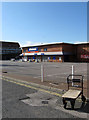
Wickes, Peacock Industrial Estate
The builders merchants lie in what was once a railway coal siding with just the arches beyond the store a reminder of its former usage.
Image: © Simon Carey
Taken: 14 Aug 2011
0.05 miles