IMAGES TAKEN NEAR TO
Lyndhurst Road, HOVE, BN3 6FB
Introduction
This page details the photographs taken nearby to Lyndhurst Road, BN3 6FB by members of the Geograph project.
The Geograph project started in 2005 with the aim of publishing, organising and preserving representative images for every square kilometre of Great Britain, Ireland and the Isle of Man.

There are currently over 7.5m images from over14,400 individuals and you can help contribute to the project by visiting https://www.geograph.org.uk
Image Map
Images are licensed for reuse under creativecommons.org/licenses/by-sa/2.0
Notes
- Clicking on the map will re-center to the selected point.
- The higher the marker number, the further away the image location is from the centre of the postcode.
Image Listing (159 Images Found)
Images are licensed for reuse under creativecommons.org/licenses/by-sa/2.0
Image
Details
Distance
1
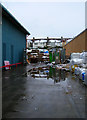
Peacock Industrial Estate
Flotsam and Jetsam between two of the warehouses with the roofs of the houses in Lyndhurst Road in the background.
Image: © Simon Carey
Taken: 6 Apr 2008
0.04 miles
2
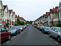
Lyndhurst Road
This road runs parallel with the railway. The estate was originally built between 1907-1913.
Image: © Simon Carey
Taken: 9 Jul 2006
0.04 miles
3

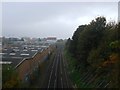
West Coastway Line from Holland Bridge
The industrial estate to the left was once sidings for a coal yard. They were closed in the early 1970s and the Peacock Industrial estate built on them.
Image: © Simon Carey
Taken: 3 Sep 2006
0.04 miles
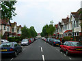
4
Glendale Road
A small suburban street that links the A270 Old Shoreham Road with Lyndhurst Road. This view looks north from the latter towards the playing fields on the far side of the former.
Image: © Simon Carey
Taken: 5 Feb 2006
0.04 miles
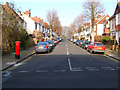
5
Ferndale Road
One of four roads that links Lyndhurst Avenue with Old Shoreham Road. This view looks south towards the former. This estate was laid out in the early 1900s with the first house constructed in 1907.
Image: © Simon Carey
Taken: 25 Jun 2006
0.05 miles
6
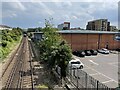
Coastway West
Viewed from Montefiore Road bridge and looking towards Holland Road bridge. The original Hove station was built on this side of the latter and operated from 1840 until the 1880s when it was closed being usurped by the current station that was built in the early 1860s. What did survive was an extensive goods yard to the left later known as Holland Road Goods Yard until that too closed around 1970. See https://www.flickr.com/photos/31890193@N08/13941540382/ for a view from Holland Road bridge taken in 1971. After the rails were lifted it became a builders yard with the current industrial estate not developed until the mid 1980s.
Just visible on the left hand side are the floodlights belonging to the County Ground, Sussex.
Image: © Simon Carey
Taken: 1 Nov 2015
0.06 miles
7
Hove 1st railway station (site), Sussex
Opened in 1840 by the London & Brighton Railway on what is today the line from Brighton to Portsmouth, this station closed in 1880.
View east towards Brighton. After closure to passengers, this site was used as a goods station until the 1970s. The original station building would have been where the small tree now is.
Image: © Nigel Thompson
Taken: 13 Jul 2021
0.07 miles
8
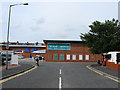
Lyons Close
Home to the Peacock Industrial Constructed opened in the 1980s on the site of a former railway coal yard. Allied Carpets has recently gone into administration so it will be interesting to see whether they remain here.
Image: © Simon Carey
Taken: 20 Jul 2009
0.07 miles
9
Lyon Close
Small industrial estate built on the site of a former coal depot and siding.
Image: © Simon Carey
Taken: 18 Dec 2009
0.07 miles
10
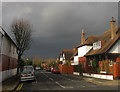
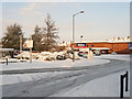
Silverdale Avenue
Residential street that heads west off Silverdale Road then turns south to join Lyndhurst Road. Currently basking in a bit of sunshine before the coming raincloud arrives.
Image: © Simon Carey
Taken: 25 Nov 2009
0.07 miles