IMAGES TAKEN NEAR TO
Old Shoreham Road, HOVE, BN3 6ET
Introduction
This page details the photographs taken nearby to Old Shoreham Road, BN3 6ET by members of the Geograph project.
The Geograph project started in 2005 with the aim of publishing, organising and preserving representative images for every square kilometre of Great Britain, Ireland and the Isle of Man.

There are currently over 7.5m images from over14,400 individuals and you can help contribute to the project by visiting https://www.geograph.org.uk
Image Map
Images are licensed for reuse under creativecommons.org/licenses/by-sa/2.0
Notes
- Clicking on the map will re-center to the selected point.
- The higher the marker number, the further away the image location is from the centre of the postcode.
Image Listing (138 Images Found)
Images are licensed for reuse under creativecommons.org/licenses/by-sa/2.0
Image
Details
Distance
1
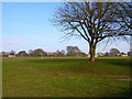
Playing Fields, Old Shoreham Road
Looking north east from the A270 Old Shoreham Road at the very edge of the square.
Image: © Simon Carey
Taken: 5 Feb 2006
0.02 miles
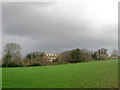
2
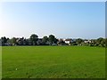
Playing Fields, BHASVIC, Hove
The fields are bounded by BHASVIC (Brighton & Hove Sixth Form College) to the east, the Cliftonville Spur railway line to the west, Old Shoreham Road to the south and Dyke Road Park to the north. The section in view is on the western side near the railway with the floodlights of the County Ground visible in the distance. For a long time there has been questions over the ownership of the land which was resolved over the summer of 2015 whereby the pitches adjacent to BHASVIC in the east belonging to the college and the rest under ownership of Brighton & Hove Council. Although not designated a public park it has long been used by the locals as an open space which at times has run into conflict with neighbouring Cardinal Newman School who use the field as extra space for PE lessons and are responsible for its maintenance. In 2013 the site was selected by Michael Gove as the preferred site of a new free school which at least united the various parties in opposition which was eventually successful. As such it remains an open space though since September 2015 the council has banned dogs from most of the fields particularly during the week when in use.
The field was originally a large triangular piece of pasture between Old Shoreham Road and Dyke Road that had become allotments by 1911 then subdivided between Dyke road park to the north and playing fields to the south during the inter-war years.
Image: © Simon Carey
Taken: 4 Oct 2015
0.02 miles
3
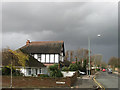
Old Shoreham Road
The A270 taken from the junction with Silverdale Road with a looming rain cloud overhead. Prior to the Brighton by-pass opening this was the A27.
Image: © Simon Carey
Taken: 25 Nov 2009
0.04 miles
4
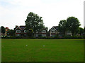
Old Shoreham Road from BHASVIC Playing Fields
The houses are between Glendale and Silverdale Road. Old Shoreham Road was once the main A27 trunk road now superseded by the bypass. The road follows the course of an old Roman Road to a former ferry crossing at Shoreham.
Image: © Simon Carey
Taken: 27 Aug 2006
0.05 miles
5
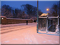
Bridge, Old Shoreham Road
Crossing the Cliftonville Spur. After the biggest fall of snow in the city for 18 years public transport ground to halt so this was the first of many people walking to work this morning.
Image: © Simon Carey
Taken: 2 Feb 2009
0.06 miles
6
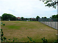
Bhasvic Playing Fields
Bhasvic is the general term used for Brighton and Hove Sixth Form College. Although primarily a private facility, ease of access means many others use the fields too. At present there is talk of selling part of the fields for housing.
Image: © Simon Carey
Taken: 23 Jul 2006
0.06 miles
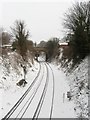
7
Cliftonville Spur
Another view of Image which can be seen clearer in this picture. The spur links the West Coastway Line with the main London-Brighton line without having to go into Brighton.
Image: © Simon Carey
Taken: 18 Dec 2009
0.06 miles
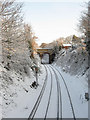
8
Cliftonville Spur
Opened in 1879 to connect the west coast line with the main London-Brighton line without the need to reverse or change engines at Brighton. Viewed from Burton Walk footbridge and looking towards Old Shoreham Road Bridge with the southern portal of Cliftonville Tunnel visible beyond.
Image: © Simon Carey
Taken: 12 Mar 2013
0.06 miles
9
BHASVIC Playing Fields
BHASVIC is the local acronym used for Brighton, Hove and Sussex Sixth Form College and the fields between Dyke Road Park and Old Shoreham Road are private and belong to the college. The trees mark the location of a cutting prior to the Cliftonville Spur heading through a tunnel on to way to Preston Park station. The building beyond is part of Cardinal Newman school. As the sky suggests it is about to rain.
Image: © Simon Carey
Taken: 25 Nov 2009
0.07 miles
10
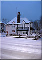
Old Shoreham Road
House on the corner of the A270 and Glendale Road. A fair number of houses in Brighton & Hove are white which go well when there is snow.
Image: © Simon Carey
Taken: 2 Feb 2009
0.07 miles