IMAGES TAKEN NEAR TO
Highdown Road, HOVE, BN3 6EE
Introduction
This page details the photographs taken nearby to Highdown Road, BN3 6EE by members of the Geograph project.
The Geograph project started in 2005 with the aim of publishing, organising and preserving representative images for every square kilometre of Great Britain, Ireland and the Isle of Man.

There are currently over 7.5m images from over14,400 individuals and you can help contribute to the project by visiting https://www.geograph.org.uk
Image Map (Loading...)


Getting Data...Please wait
Leaflet Map data © OpenStreetMap
Images are licensed for reuse under creativecommons.org/licenses/by-sa/2.0
Notes
- Clicking on the map will re-center to the selected point.
- The higher the marker number, the further away the image location is from the centre of the postcode.
Image Listing (216 Images Found)
Images are licensed for reuse under creativecommons.org/licenses/by-sa/2.0
Image
Details
Distance
1
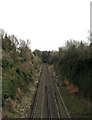
East Coastway Line
Taken from Montefiore Road bridge and looking towards the tunnel that takes it under Dyke Road and the surrounding area.
Image: © Simon Carey
Taken: 15 Feb 2009
0.03 miles
2
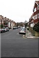
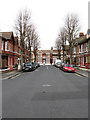
Caburn Road
Small residential street linking Highdown Road with Old Shoreham Road and developed between 1896-1900.
Image: © Simon Carey
Taken: 15 Feb 2009
0.04 miles
3
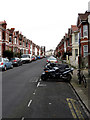
Addison Road
Looking towards the eastern junction with Dyke Road. The road was developed in the 1890s but only as far as Julian Road before it was extended to its final junction in 1902.
Image: © Simon Carey
Taken: 15 Feb 2009
0.05 miles
4
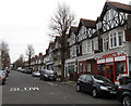
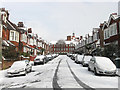
Highdown Road
Linking Dyke Road with Montefiore Road and running parallel with Old Shoreham Road to the north and the railway to the south. This set of houses look suspiciously like an old parade of shops with only the launderette remaining in use though there is a chartered accountant occupying the last of this row.
Image: © Simon Carey
Taken: 15 Feb 2009
0.06 miles
5
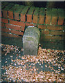
Old Boundary Marker by the A270, Old Shoreham Road, Hove
Parish Boundary Marker by the A270, in parish of Hove (Brighton and Hove District), against a brick wall on the South side of the junction of the A270 Old Shoreham Road and the A2010 Dyke Road.
Surveyed
Milestone Society National ID: SX_HVPR01pb
Image: © Milestone Society
Taken: Unknown
0.06 miles
6
Osmond Road
Looking towards the northern junction with Addison Road.
Image: © Simon Carey
Taken: 15 Feb 2009
0.08 miles
7
Wolstonbury Road
A residential road linking Highdown Road to Old Shoreham Road. The buildings at the end of the street belong to BHASVIC, a local sixth form college.
Image: © Simon Carey
Taken: 12 Mar 2013
0.08 miles
8
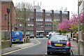
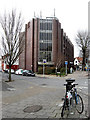
Ridgeland House, Dyke Road, Brighton
Offices and retail, seen from Russell Crescent.
Image: © Robin Webster
Taken: 30 Apr 2010
0.08 miles
10
Ridgeland House
Office block on the corner of Dyke Road and Addison Road including HSBC amongst others.
Image: © Simon Carey
Taken: 15 Feb 2009
0.08 miles