IMAGES TAKEN NEAR TO
Leicester Villas, HOVE, BN3 5SP
Introduction
This page details the photographs taken nearby to Leicester Villas, BN3 5SP by members of the Geograph project.
The Geograph project started in 2005 with the aim of publishing, organising and preserving representative images for every square kilometre of Great Britain, Ireland and the Isle of Man.

There are currently over 7.5m images from over14,400 individuals and you can help contribute to the project by visiting https://www.geograph.org.uk
Image Map
Images are licensed for reuse under creativecommons.org/licenses/by-sa/2.0
Notes
- Clicking on the map will re-center to the selected point.
- The higher the marker number, the further away the image location is from the centre of the postcode.
Image Listing (103 Images Found)
Images are licensed for reuse under creativecommons.org/licenses/by-sa/2.0
Image
Details
Distance
1
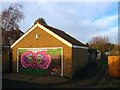
Garage, Leicester Villas, Aldrington, Hove
Adorned with a rather colourful owl painted by local artist, Harpoart. The garage is located at the end of the access drive to St Christopher's School playing field.
Image: © Simon Carey
Taken: 22 Dec 2016
0.02 miles
2
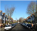
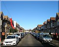
Leicester Villas, Aldrington, Hove
A residential road linking New Church Road, the B2066, with Portland Road that was laid out on the 1911 OS map but not completed until the 1920s.
Image: © Simon Carey
Taken: 22 Dec 2016
0.03 miles
4
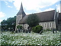
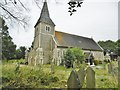
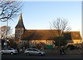
St Leonards Church, Aldrington
St Leonard's is the Parish church of Aldrington,
The first church on this site was built in the 13th century but after years of decay it was rebuilt starting from 1875 and extebnded in 1938
http://en.wikipedia.org/wiki/St_Leonard's_Church,_Aldrington
Image: © Paul Gillett
Taken: 26 May 2009
0.06 miles
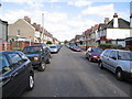
5
Worcester Villas, Aldrington, Hove
A residential road that links New Church Road, the B2066, with Portland Road that was developed in the first decade of the 20th century. See http://regencysociety-jamesgray.com/volume16/source/jg_16_069.html for a similar view taken in 1914.
Image: © Simon Carey
Taken: 22 Dec 2016
0.07 miles
6
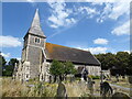
Aldrington, St. Leonard's
Parish church on New Church Road. Late C19, on a much earlier site; Grade II listed by Historic England: http://www.imagesofengland.org.uk/Details/Default.aspx?id=365598&mode=adv
Image: © Mike Faherty
Taken: 11 Aug 2018
0.07 miles
9
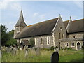
St Leonards Church, Aldrington, Hove
The current church dates from 1878 with the extension on the eastern side added in the late 1920s. The original parish church was constructed in the 13th century but was in ruins by the 17th after the population within the parish declined. When development began in the late 19th century it was decided to rebuild the church using remaining masonry and as close to the original design as possible.
See:
Church in ruins 1859 - http://regencysociety-jamesgray.com/volume15/source/jg_15_138.html
Church in ruins 1870 - http://regencysociety-jamesgray.com/volume15/source/jg_15_139.html
Being rebuilt 1877 - http://regencysociety-jamesgray.com/volume15/source/jg_15_148.html
Newly rebuilt 1878 - http://regencysociety-jamesgray.com/volume15/source/jg_15_140.html
Pre-extension 1894 - http://regencysociety-jamesgray.com/volume15/source/jg_15_142.html
Image: © Simon Carey
Taken: 3 Dec 2016
0.08 miles
10
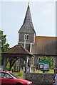
Church of St Leonard
Grade II listed. http://www.britishlistedbuildings.co.uk/en-365598-church-of-st-leonard-
Image: © N Chadwick
Taken: 4 Jul 2015
0.08 miles